Jarðfræðikort af Austurlandi 1. útgáfa – 1:100.000

Gagnasafn (GDB) NI_J100v_Austurland_1.utg:
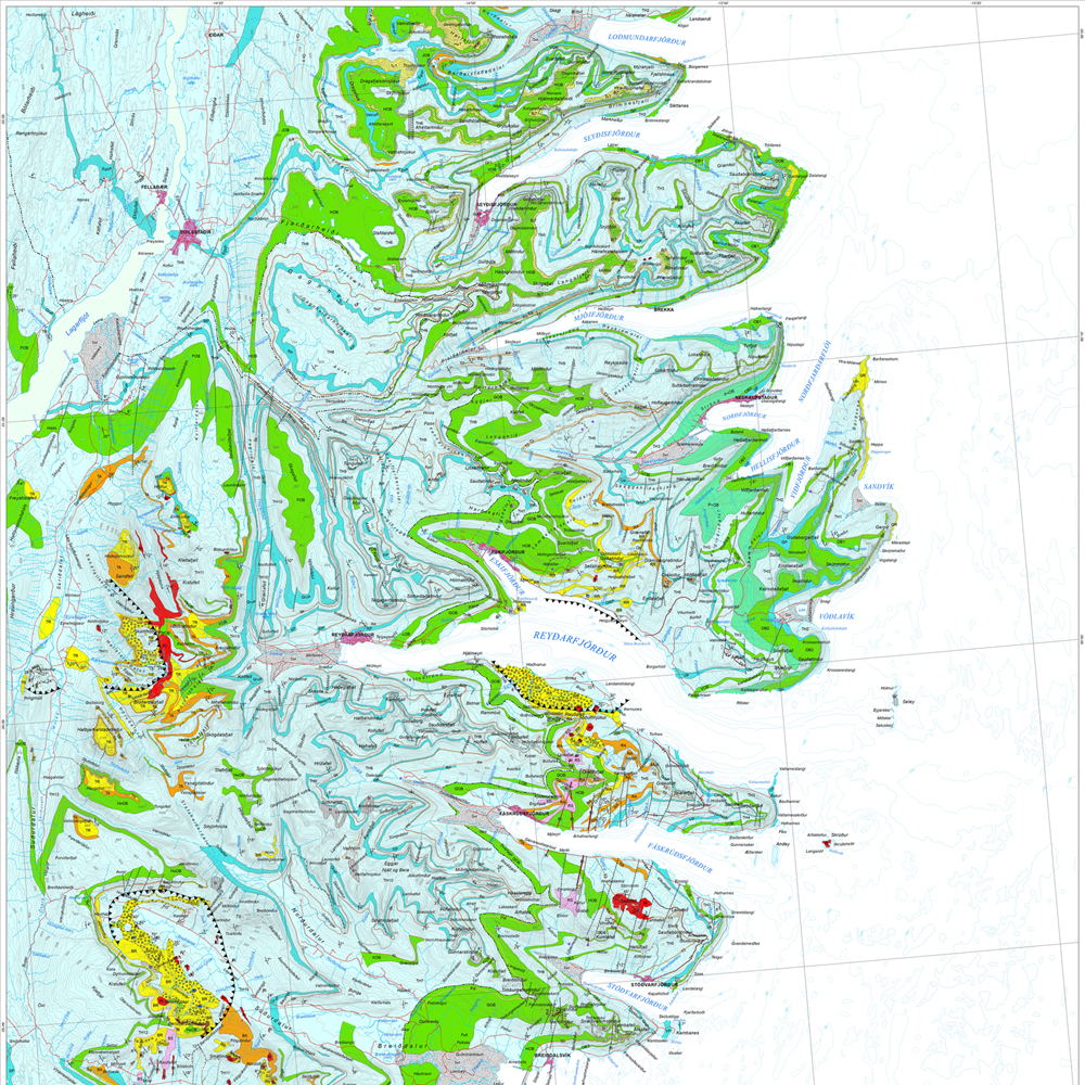
Jarðfræðikort af Austurlandi í mælikvarði 1:100.000, 1. útg. [Geological map of Eastern Iceland in the scale of 1:100.000, 1st ed.]
Jarðfræðikort af Austurlandi nær yfir svæði frá Berufirði yfir í Mjóafjörð. Berggrunnur er flokkaður eftir gerð og samsetningu. Kortið sýnir túff (gjóskulög), gíga, öskjurima, sprungur, misgengi, strik og halla, framhlaup, steingervinga, lindir og mörk segulskeiðsins C5n.
[The Geological map of Eastern Iceland covers the area from Berufjörður up to Mjóifjörður. Bedrock is classified by type and composition. The map shows tuff layers, craters, caldera rims, fissures, faults, strike and dip, landslides, fossils, springs and the base of magnetic chron C5n.]
Jarðfræðikort af Austurlandi – smámynd
dataset
ni:ni_j100v_austurland_berggrunnur_1utg_fl
- Jarðfræði Austurland berggrunnur
ni:ni_j100v_austurland_berggrunnur_mork_1utg_li
- Jarðfræði Austurland berggrunnur mörk
ni:ni_j100v_austurland_millilog_1utg_li
- Jarðfræði Austurland millilög
ni:ni_j100v_austurland_anomalia_c5n_1utg_li
- Jarðfræði Austurland segulanomalia
ni:ni_j100v_austurland_gigar_1utg_li
- Jarðfræði Austurland gígar - línur
ni:ni_j100v_austurland_gigar_1utg_fl
- Jarðfræði Austurland gígar - svæði
ni:ni_j100v_austurland_hoggun_1utg_li
- Jarðfræði Austurland höggun
ni:ni_j100v_austurland_steingervingar_1utg_p
- Jarðfræði Austurland steingervingar
ni:ni_j100v_austurland_skridur_1utg_li
- Jarðfræði Austurland skriður
ni:ni_j100v_austurland_strik_halli_1utg_p
- Jarðfræði Austurland halli
:
?
Icelandic
Geoscientific information
GEMET - INSPIRE themes, version 1.0:
GSL flokkun:
Geology
Free:
National
Free:
GSL
-14.775,
64.59,
-13.431,
65.409
publication: 2019-12-31
2019-06-30
-
2019-12-31
onGoing
vector
?
Náttúrufræðistofnun – Natural Science Institute of Iceland
?
,
?,
?
tel: ?
email:
[email protected]
Role: originator
Data Quality
Höfundar kortsins eru Birgir V. Óskarsson og Morten S. Riishuus jarðfræðingar sem unnu að kortlagningu svæðisins og tengingu eldri korta. Sjá heimildir á útprentuðu korti (Birgir V. Óskarsson og Morten S. Riishuus 2019. Jarðfræðikort af Austurlandi. 1:100.000. 1. útg. Garðabær: Náttúrufræðistofnun Íslands). Sjá nánar með hvert lög.
[The authors of the map are Birgir V. Óskarsson and Morten S. Riishuus geologists that compiled the maps and correlated and mapped the geological layers and formations. See reference list in printed map (Óskarsson, B.V. and Riishuus, M.S. 2019. Geological Map of Eastern Iceland. 1:100 000. 1st edition. Garðabær: Icelandic Institute of Natural History). See more detailed information at the individual layers.]
[The authors of the map are Birgir V. Óskarsson and Morten S. Riishuus geologists that compiled the maps and correlated and mapped the geological layers and formations. See reference list in printed map (Óskarsson, B.V. and Riishuus, M.S. 2019. Geological Map of Eastern Iceland. 1:100 000. 1st edition. Garðabær: Icelandic Institute of Natural History). See more detailed information at the individual layers.]
Equivalent Scale:
1:
100000
Constraints
https://www.natt.is/is/midlun/opin-gogn
Gögnin eru öllum opin – no limitations on public access
Metadata about metadata
c907fbd3-7420-4c0b-81e4-b877514ba8c5
Náttúrufræðistofnun – Natural Science Institute of Iceland
?
?,
?,
?,
?
tel: ?
email:
[email protected]
Role: point of contact
2025-12-04