ni_j100v Berggrunnur á Austurlandi – 1:100.000

Þekja (layer) j100v_austurland_berggrunnur_1utg_fl:
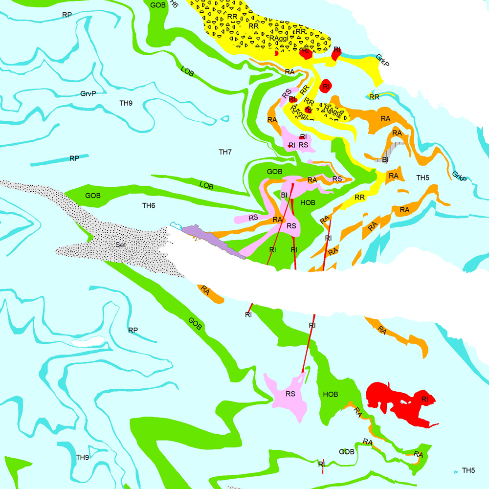
Gögn sem sýnir bergrunn Austurlands. [Data showing the bedrock geology of Eastern Iceland.]
Flákalag með bergrunn Austurlands. Flákarnir sýna mismunandi gerðir storkubergs ásamt sethulu. Gögn eru flokkuð eftir ÍST120:2012 staðlinum, nema þrjá fitjueigindir:
myndunKodi = Heiti myndunarinnar (skammstöfun)
myndunIS = Heiti myndunarinnar (á íslenskuc)
myndunEN = Heiti myndunarinnart (á ensku)
Nýr kóði fyrir fitjueigindi 'Tegund storkubergs' (tegStorkubergs): shra = samsett hraun, dbas = Dílabasalt, dobas = Díla- og olívínbasalt, and = Andesít.
[Polygone layer of the bedrock geology of Eastern Iceland. The polygones show different classes of intrusive and extrusive rocks and the sediment cover. The data follows the ÍST120:2012 data standard with the three additional feature attributes:
myndunKodi = Lithostratigraphic unit (abbreviation)
myndunIS = Lithostratigraphic unit (in Icelandic)
myndunEN = Lithostratigraphic unit (in English)
New codes for feature attribute 'Tegund storkubergs' (tegStorkubergs) are: shra = composit lava, dbas = porphyritic lava, dobas = porphyritic and olivine basalt, and = andesite.]
Berggrunnur – smámynd
dataset
ni:ni_j100v_austurland_berggrunnur_1utg_fl
- Jarðfræði Austurland berggrunnur
Icelandic
Geoscientific information
GEMET - INSPIRE themes, version 1.0:
GSL flokkun:
Geology
Free:
GSL
Free:
National
-14.775,
64.59,
-13.431,
65.409
publication: 2019-12-31
2019-06-30
-
2019-12-31
onGoing
vector
?
Náttúrufræðistofnun – Natural Science Institute of Iceland
?
,
?,
?
tel: ?
email:
[email protected]
Role: originator
Data Quality
Gögnin eru að mestu byggð á eldri jarðfræðikortum sem til eru af svæðinu, einkum eftir breska jarðfræðinginn George P.L. Walker sem starfaði á Austurlandi á árunum 1954–1965. Höfundar kortsins eru Birgir V. Óskarsson og Morten S. Riishuus jarðfræðingar sem unnu að kortlagningu svæðisins og tengingu eldri korta. Sjá heimildir á útprentuðu korti (Birgir V. Óskarsson og Morten S. Riishuus 2019. Jarðfræðikort af Austurlandi. 1:100.000. 1. útg. Garðabær: Náttúrufræðistofnun Íslands).
[The data is mostly built on the maps of the british geologist George P.L. Walker that worked in Eastern Iceland in between 1954–1965. The authors of the map are Birgir V. Óskarsson and Morten S. Riishuus geologists that compiled the maps and correlated and mapped the geological layers and formations. See reference list in printed map (Óskarsson, B.V. and Riishuus, M.S. 2019. Geological Map of Eastern Iceland. 1:100 000. 1st edition. Garðabær: Icelandic Institute of Natural History).]
[The data is mostly built on the maps of the british geologist George P.L. Walker that worked in Eastern Iceland in between 1954–1965. The authors of the map are Birgir V. Óskarsson and Morten S. Riishuus geologists that compiled the maps and correlated and mapped the geological layers and formations. See reference list in printed map (Óskarsson, B.V. and Riishuus, M.S. 2019. Geological Map of Eastern Iceland. 1:100 000. 1st edition. Garðabær: Icelandic Institute of Natural History).]
Equivalent Scale:
1:
100000
Constraints
https://www.natt.is/is/midlun/opin-gogn
Gögnin eru öllum opin – no limitations on public access
Metadata about metadata
99e816ff-e9a1-4fe0-a981-33daf89e594a
Náttúrufræðistofnun – Natural Science Institute of Iceland
?
?,
?,
?,
?
tel: ?
email:
[email protected]
Role: point of contact
2025-08-07