Service of visualization (WMS) of the Neotectonic Map of Spain at a scale of 1:1,000,000


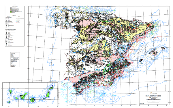
The Neotectonic Map expresses those structural, morphological, stratigraphic and other features that show relatively recent movements (from the period considered neotectonic), as well as the type of stress to which the peninsula is subjected. Its objectives are to identify deformations from the Middle Miocene - Upper Miocene boundary to the present day. The materials have been classified into six categories, two for volcanic materials differentiated by age; and four for the rest of the materials, with four subdivisions according to age. It also includes tectonic structures, stress and deformation directions, diapiric structures and other related phenomena, all with age expression. The map contains information on the Spanish continental shelf.
large_thumbnail
service
- Servicio
Link to GetCapabilities of the web service hosting the product
- URL de acceso
IGME-CSIC
:
WMS_NEOTECTONICO1000
view
GEMET - INSPIRE themes, version 1.0:
 Spatial scope:
INSPIRE_SpatialDataServicesClassification:
ISO 19119:
Web Services Specifications:
Spatial scope:
INSPIRE_SpatialDataServicesClassification:
ISO 19119:
Web Services Specifications:
Map access service
infoMapAccessService
Geographic modelling/information management service
infoManagementService
OGC (Open Geospatial Consortium)
WMS (Web Map Service)
WMS 1.3.0
OGC
WMS
Free:
IGME
IDEE
Neotectonic
Spain
Free:
EGDI
-18.167,
27.642,
4.337,
43.793
publication: 2010-08-16
Geological Survey of Spain (IGME-CSIC)
?
email:
[email protected]
Role: point of contact
Data Quality
Commission Regulation (EU) No 1089/2010 of 23 November 2010 implementing Directive 2007/2/EC of the European Parliament and of the Council as regards the interoperability of spatial data sets and services
Constraints
LICENCE OF USE: Conditions of public use and dissemination of information for the re-use of IGME data. https://www.igme.es/condiciones-de-uso/
Metadata about metadata
ESPIGMESERVICIONEOTECTONICO100020120404
Geological Survey of Spain (IGME-CSIC)
Leticia Vega Martín
C/ Ríos Rosas, 23,
Madrid,
28003,
España
tel: +34 91 349 57 00
email:
[email protected]
Role: point of contact
2026-06-04