Neotectonic Map of Spain at a scale of 1:1,000,000


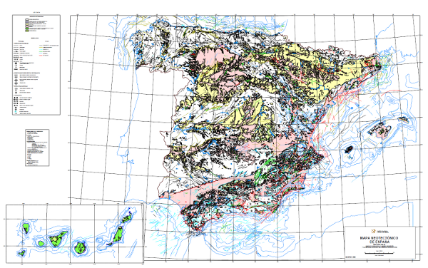
The Neotectonic Map expresses those structural, morphological, stratigraphic and other features that show relatively recent movements (from the period considered neotectonic), as well as the type of stress to which the peninsula is subjected. Its objectives are to identify deformations from the Middle Miocene - Upper Miocene boundary to the present day. The materials have been classified into six categories, two for volcanic materials differentiated by age; and four for the rest of the materials, with four subdivisions according to age. It also includes tectonic structures, stress and deformation directions, diapiric structures and other related phenomena, all with age expression. The map contains information on the Spanish continental shelf. This map, of national scope, has been produced by the Geological Survey of Spain in collaboration with the National Radioactive Waste Company (ENRESA).
large_thumbnail
dataset
- Mapa Neotectónico de España a escala 1:1.000.000
Link to the GetCapabilities of the web service hosting the product
- Map service (URL of the Capabilities file)
:
ESPIGMENEOTECTONICO1000
Spanish
Geoscientific information
INSPIRE_SpatialThemes:
IGME Thesaurus:
CEOLocation:
EuropeanTerritorialUnits:
GEMET:
GEMET - INSPIRE themes, version 1.0:
 Spatial scope:
Geology
Natural risk zones
General geology
map
tectonic map
Structural geology
neotectonics
post-tectonic process
syntectonic process
uprising
subsidence
Environmental geology
natural hazard
volcanic hazard
COUNTRIES
SPAIN
SPAIN
NATURAL ENVIRONMENT, ANTHROPIC ENVIRONMENT
LITHOSPHERE (soil, geological processes)
geological processes
volcanism
SOCIAL ASPECTS, ENVIRONMENTAL POLICY, MEASURES
RISKS, SECURITY
disasters
natural disasters
geological disasters
SOCIAL ASPECTS, ENVIRONMENTAL POLICY, MEASURES
RESEARCH, SCIENCE
science
natural sciences
earth sciences
geology
tectonics
Free:
EGDI
-18.208,
27.608,
4.315,
43.834
creation: 1990-12-03
1990-12-03T10:00:00
completed
vector
The Iberian Peninsula is an active geodynamic region with a recognised medium seismicity, either due to the occurrence of earthquakes or due to the action of slower and less sudden tectonic processes, sometimes imperceptible to man, but which in the long run have an impact on socio-economic and environmental aspects. These dynamics can eventually translate into risk to life and substantial economic losses. This map is therefore applicable in many areas of action such as land-use plans, urban planning, emergency and civil protection plans, industrial and military installations, public works and seismic prediction programmes. Always bearing in mind that its scale orients it to national or regional projects, requiring detailed studies for larger scales.
Geological Survey of Spain (IGME-CSIC)
Francisco Nozal Martín
C/ La Calera, 1,
Tres Cantos,
28760,
España
tel: +34 91 349 59 00
email:
[email protected]
Role: point of contact
Data Quality
The work began with the collection of bibliographic data and unpublished works. Subsequently, a working scale with abundant cartographic reference information was selected, which was the 1:200,000 scale. From here, reference cartographic documents were selected and analysed (topographic bases, geological information, satellite images) and the work was regionalised. Finally, various cartographic documents were produced at a scale of 1:200,000, which were used to produce the final map at a scale of 1:1,000,000 on a non-deformable support that served as a support for digitisation.
Equivalent Scale:
1:
1000000
Reglamento (CE) n.o 1205/2008 de la Comisión de 3 de Diciembre de 2008 que estabelece las modalidades de aplicación de la Directiva 2007/2/CE del Parlamento Europeo y del Consejo em materia de metadados
Reglamento (CE) n.o 1205/2008 de la Comisión de 3 de Diciembre de 2008 que estabelece las modalidades de aplicación de la Directiva 2007/2/CE del Parlamento Europeo y del Consejo em materia de metadados
Constraints
LICENCE OF USE: Conditions of public use and dissemination of information for the re-use of IGME data. https://www.igme.es/condiciones-de-uso/
Metadata about metadata
ESPIGMENEOTECTONICO10002012032126045
Instituto Geológico y Minero de España (IGME-CSIC)
Leticia Vega Martín
C/ Ríos Rosas, 23,
Madrid,
28003,
España
tel: +34 91 349 57 00
email:
[email protected]
Role: point of contact
2025-07-18
Coupled Resource
(The rock units of the sheet separated by different types of contacts are represented, together with the tectonic structure, faults and map traces of folds, the orientation and dip of planar and linear elements contained in the rocks, structural and textural singularities of igneous and metamorphic rocks, water points, mineral deposits and indications, presence of fossils and other elements of punctual representation.)
(The rock units of the sheet separated by different types of contacts are represented, together with the tectonic structure, faults and map traces of folds, the orientation and dip of planar and linear elements contained in the rocks, structural and textural singularities of igneous and metamorphic rocks, water points, mineral deposits and indications, presence of fossils and other elements of punctual representation.)