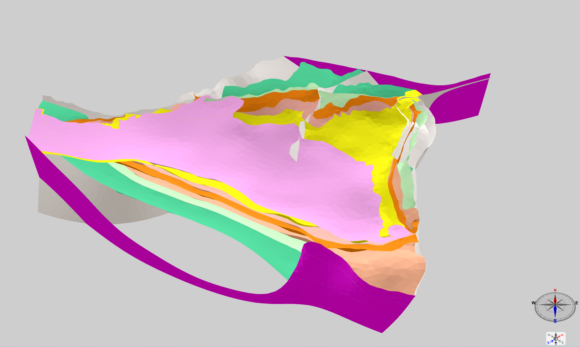
3D geological model of the Carrascal-Ferrer Aquifer


The 3D Geological Model of the Carrascal-Ferrer Aquifer is located in the northeast of Alicante Province (Spain). The aquifer spans an area of 119 km² and serves as one of the primary sources of potable and irrigation water for the La Marina Baja region. The aquifer is composed of limestones and dolomites dating from the Barremian to the Aquitanian of the Internal Prebetic of the External Zones of the Betic Cordillera. The 3D geological model was developed using the 3D Geomodeller and Gocad software. This model aims to determine the total volume of stored water reserves and to establish the geometric relationships between the differentiated aquifer units. The 3D geological model delineates seven geological units and five primary and secondary faults. Data used for constructing the 3D model include reflection seismic profiles, hydrogeological investigation boreholes, and structural geological mapping. The Carrascal-Ferrer aquifer exhibits a complex geological structure, affected by variably oriented folds, intersected by reverse faults and strike-slip faults.
large_thumbnail
dataset
3D viewer
- Web viewer of 3D geological models developed by the IGME-CSIC
https://registry.geology.es/id/ESPIGME_3D_CARRASCAL
Spanish
Geoscientific information
GEMET - INSPIRE themes, version 1.0:
 GeoERA Keyword Thesaurus:
European Geoscience Registry - Projects:
Spatial scope:
GeoERA Keyword Thesaurus:
European Geoscience Registry - Projects:
Spatial scope:
GSEU
Free:
Inventory3D
-0.206,
38.657,
-0.048,
38.732
creation: 2014-01-01, publication: 2014-01-01
min: -2000
max: 1000
CRS: Alicante height (http://www.opengis.net/def/crs/EPSG/0/5782)
completed
tin
Hydrogeological research
Carlos Marín Lechado
C/La Calera s/n,
Tres Cantos,
28760,
España
email:
[email protected]
Role: custodian
Data Quality
3D geological model developed within the HIDROPROAL project (IGME, 2014). Based on MAGNA geological mapping (sheets 822 and 848), 147 structural measurements, photointerpretation and DTM analysis, 9 geological cross-sections, 28 hydrogeological boreholes (DPA), and interpretation of seismic lines RV-70-V and RV-71-V (1985).
The model defines main stratigraphic boundaries (Miocene to Aptian-Albian) and 5 major faults over 119 km². Geometry validated through integration of surface and subsurface data. Higher uncertainty in western sector due to limited subsurface control.
The model defines main stratigraphic boundaries (Miocene to Aptian-Albian) and 5 major faults over 119 km². Geometry validated through integration of surface and subsurface data. Higher uncertainty in western sector due to limited subsurface control.
Equivalent Scale:
1:
50000
Constraints

Metadata about metadata
ESPIGMECARRASCAL3D20260307
Leticia Vega Martín
C/Ríos Rosas, 23,
Madrid,
28003,
España
email:
[email protected]
Role: point of contact
2026-03-27