Geothermal map - Expected temperatures at a depth of 100 m

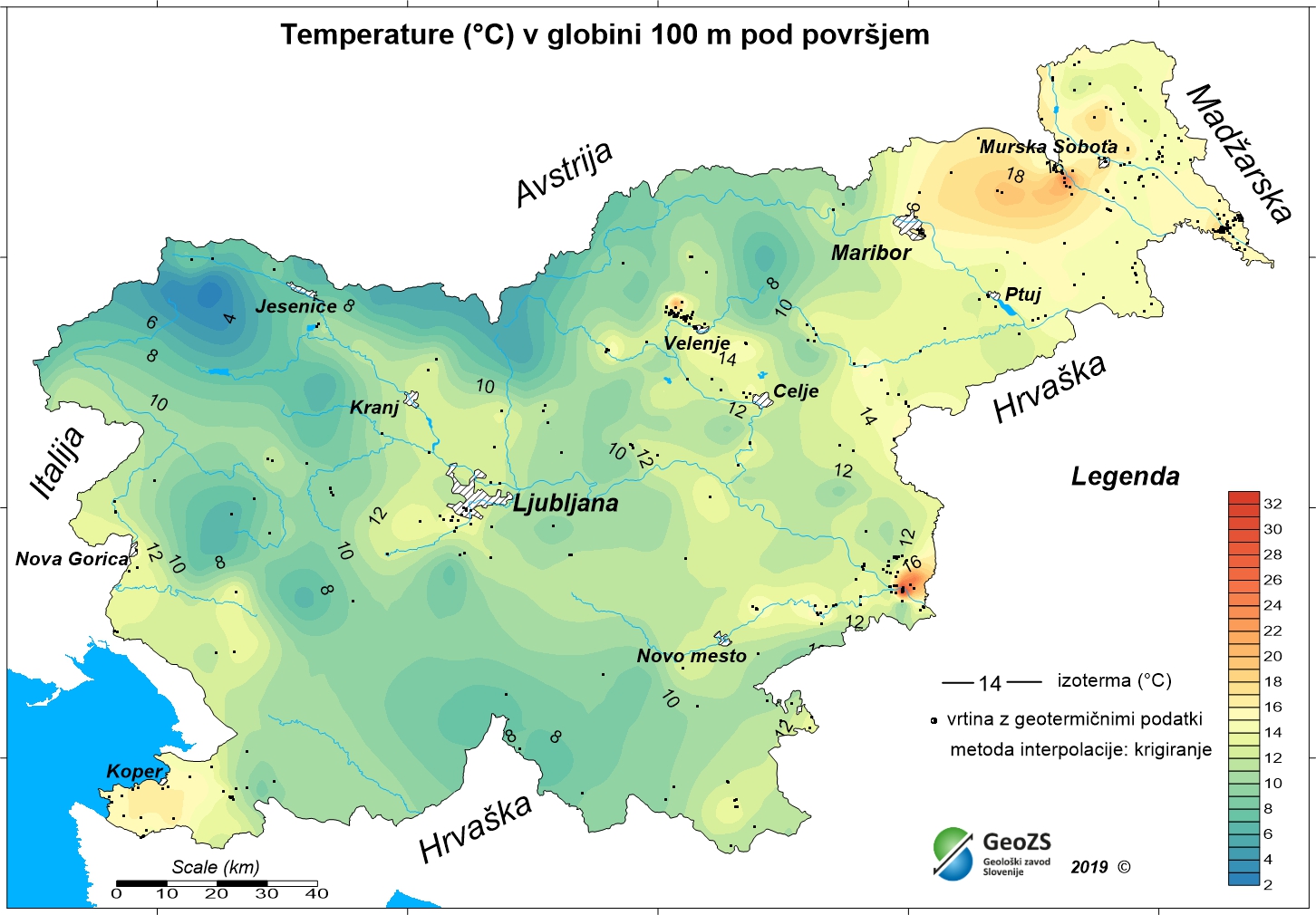
The underground geothermal conditions can be presented, irrespective of the aquifers' position, with the appropriate geothermal maps. This map represents the expected temperatures at a depth of 100 m and is made with data from 398 boreholes. It is made on the basis of measured temperatures in accessible boreholes throughout the country. However, since the temperature field depends on the geological structure in the depths and tectonic characteristics, the course of the isotherms is a result of many influences, such as thermal conductivity of rocks, permeability and fracturing of rocks, all of which are reflected in the measured temperatures in boreholes. The distribution of boreholes, which were useful for the measurement of temperature, is very uneven and different as regard the depths. Following the expected temperatures at a depth of 100 m a stronger positive anomaly is in the northeastern part of Slovenia, and in a smaller eastern part of the Krka basin. In the northeastern part of the country the anomaly is the result of the thinning of the Earth's crust and greater conductive heat flow from the Earth's mantle.
large_thumbnail
dataset
ER.t100_1km
- ?
t_100_1km.rar
- Geothermal map - Expected temperatures at a depth of 100 m
SI.GEOZS.GEOTERM.IZO.100m
:
fd5c6e21-59ca-4573-8557-1ca0ab177411
Slovenian
Geoscientific information
GEMET - INSPIRE themes, version 1.0 INSPIRE themes:
Spatial scope:
Energy resources
National
Free:
Slovenia
Free:
geothermal energy
geothermy
temperature map
temperature at 100 m depth
renewable energy resources
energy balance
hydrogeology
EGDI
Free:
INSPIRE
13.38,
45.42,
16.6,
46.88
creation: 2012-12-31
grid
The purpose of the maps is to improve insight in the geothermal conditions in the depths. With the latest geothermal maps better insight into the geothermal field of Slovenia has been obtained, especially at greater depths. The research results are potentially useful in planning future more detailed studies for the exploitation of geothermal energy. Ultimately, this means determining the micro locations for drilling deep exploration boreholes and exploitation boreholes or wells.
Geological Survey of Slovenia
Dimičeva ulica 14,
Ljubljana,
1000,
Slovenija
tel: +386 1 280 97 00
email:
[email protected]
Role: owner
Ministry of Infrastructure
Langusova ulica 4,
Ljubljana,
1000,
Slovenija
tel: ?
email:
[email protected]
Role: originator
Geological Survey of Slovenia
mag. Andrej Lapanje
Dimičeva ulica 14,
Ljubljana,
1000,
Slovenija
tel: +386 1 28 09 700
email:
[email protected]
Role: point of contact
Geological Survey of Slovenia
mag. Dušan Rajver
Dimičeva ulica 14,
Ljubljana,
1000,
Slovenija
tel: +386 1 28 09 700
email:
[email protected]
Role: point of contact
Geološki zavod Slovenije
?
Dimičeva ulica 14,
Ljubljana,
1000,
Slovenija
tel: +386 1 280 97 00
email:
[email protected]
Role: custodian
Data Quality
Authors:
mag. Dušan Rajver, univ.dipl.ing.geol., dr. Mitja Janža, univ.dipl.ing.geol., mag. Andrej Lapanje, univ.dipl.ing.geol.
mag. Dušan Rajver, univ.dipl.ing.geol., dr. Mitja Janža, univ.dipl.ing.geol., mag. Andrej Lapanje, univ.dipl.ing.geol.
Minimal Distance:
1000 m
Constraints
Metadata about metadata
c03497ab-a7ec-4952-9222-06bf3f2dcae9
Geological Survey of Slovenia
Rada Peternel Rikanovič
Dimičeva ulica 14,
Ljubljana,
1000,
Slovenija
tel: +386 1 28 09 700
email:
[email protected]
Role: point of contact
2026-03-02
Coupled Resource
(RAZISKAVE NACIONALNEGA POMENA; Naloga: 3.3 GEOTERMALNI VIRI, december 2012
vir zajema: dokumentacija Geološkega zavoda Slovenije)
vir zajema: dokumentacija Geološkega zavoda Slovenije)