View Service (WMS) of Geological Map of Spain and Portugal ar scale 1:1.000.000


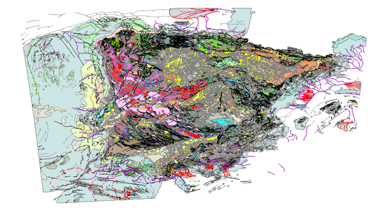
View service for the new Geological Map of Spain and Portugal at a scale of 1:1,000,000, published in 2015. This is the most up-to-date version of the geological cartography of the Iberian Peninsula, as well as Ceuta and Melilla, and the entire island territory of Spain and Portugal: the Balearic Islands, the Canary Islands, the Azores, and Madeira. For the first time, this version includes the geological cartography of the continental shelf of both countries and of the Atlantic islands. This map brings together all the geological knowledge contributed by the MAGNA series of 1:50,000 scale geological cartography by the IGME for Spanish territory, and the systematic geological cartography of Portugal carried out by the LNEG. The continental part of the map has been drawn up using previous 1:400,000 scale summaries prepared for each of the main geological units of Spain, namely the Variscan Massif, the Pyrenees, the Betic Mountains, the Cantabrian and Iberian Mountains and the basins of the Duero, Tagus and Ebro rivers, and the 1:200,000 scale geological mapping carried out in Portugal.
large_thumbnail
service
- Servicio
view
GEMET - INSPIRE themes, version 1.0:
 ISO - 19119 geographic services taxonomy:
INSPIRE_SpatialDataServicesClassification:
GEOLocation:
EuropeanTerritorialUnits:
Spatial scope:
ISO 19119:
Especificaciones de Servicios Web:
ISO - 19119 geographic services taxonomy:
INSPIRE_SpatialDataServicesClassification:
GEOLocation:
EuropeanTerritorialUnits:
Spatial scope:
ISO 19119:
Especificaciones de Servicios Web:
infoMapAccessService
Servicio de acceso a mapas
Servicio de gestión de modelos/información geográficos
COUNTRIES
SPAIN
PORTUGAL
ESPAÑA
PORTUGAL
OGC (Open Geospatial Consortium)
WMS (Web Map Service)
WMS 1.3.0
OGC
WMS
Free:
IGME
IDEE
Mapa Geológico
Free:
España
Portugal
Baleares
Canarias
Azores
Madeira
Free:
IGME
LNEG
Official Geological Mapping
Geological Map
Free:
EGDI
-22.719,
26.602,
6.257,
44.66
publication: 2018-07-20
Disponibilidad on-line del Mapa Geológico de España y Portugal a escala 1:1.000 000.
Geological Survey of Spain (IGME-CSIC)
email:
[email protected]
Role: point of contact
Data Quality
Commission Regulation (EU) No 1089/2010 of 23 November 2010 implementing Directive 2007/2/EC of the European Parliament and of the Council as regards the interoperability of spatial data sets and services
COMMISSION REGULATION (EC) No 1205/2008 of 3 December 2008 implementing Directive 2007/2/EC of the European Parliament and of the Council as regards metadata
Constraints
LICENSE OF USE: Conditions of public use and dissemination of information for the reuse of data. https://www.igme.es/condiciones-de-uso/
Metadata about metadata
ESPIGMESERVICIOGEOLOGICO1000ESPANAYPORTUGAL20180427
Geological Survey of Spain (IGME-CSIC)
Leticia Vega Martín
?,
Madrid,
28003
tel: +34 91 349 57 41
email:
[email protected]
Role: point of contact
2025-08-01