Service of visualization (WMS) of the Quaternary Map of Spain at scale of 1:1,000,000


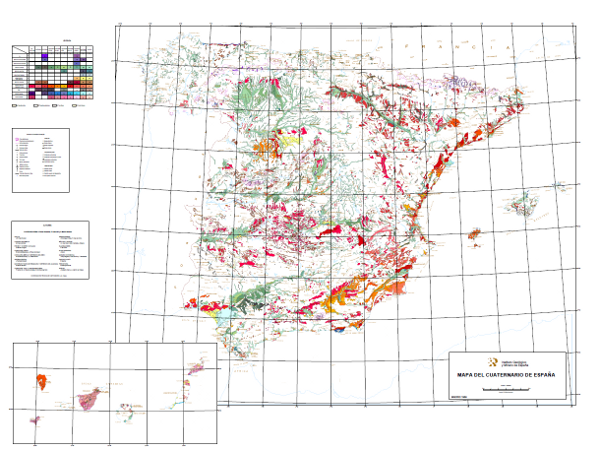
This map shows deposits dated as Plio-Pleistocene to contemporary, classified in 10 geochronological intervals and separated according to their genesis. Glacial, volcanic, karstic, aeolian, littoral, edaphic, palaeontological and prehistoric entities are included.
large_thumbnail
service
- Servicio
IGME-CSIC
:
WMS-CUATERNARIO1000
view
INSPIRE_SpatialDataServicesClassification:
IGME Thesaurus:
GEMET - INSPIRE themes, version 1.0:
 ISO 19119:
Web Services Specifications:
Spatial scope:
ISO 19119:
Web Services Specifications:
Spatial scope:
Map access service
infoMapAccessService
Geographic modelling/information management service
infoManagementService
Quaternary Geomorphology and Geology
OGC (Open Geospatial Consortium)
WMS (Web Map Service)
WMS 1.3.0
OGC
WMS
Free:
IGME
IDEE
Quaternary
Free:
EGDI
-22.716,
26.589,
6.338,
44.654
publication: 2009-03-01
Geological Survey of Spain (IGME-CSIC)
?
email:
[email protected]
Role: point of contact
Data Quality
Commission Regulation (EU) No 1089/2010 of 23 November 2010 implementing Directive 2007/2/EC of the European Parliament and of the Council as regards the interoperability of spatial data sets and services
Constraints
LICENCE OF USE: Conditions of public use and dissemination of information for the re-use of IGME data. https://www.igme.es/condiciones-de-uso/
Metadata about metadata
ESPIGMESERVICIOCUATERNARIO10002011021561120
Geological Survey of Spain (IGME-CSIC)
Leticia Vega Martín
C/ Ríos Rosas, 23,
Madrid,
28003,
España
tel: +34 91 349 57 00
email:
[email protected]
Role: point of contact
2025-07-18