Lithological Map of the Iberian Peninsula, Balearic and Canary Islands at scale 1:1.000.000


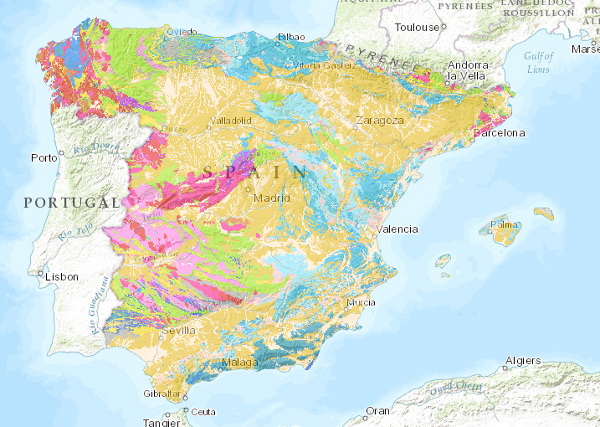
The Lithological Map of the Iberian Peninsula, Balearic and Canary Islands at a scale of 1:1,000,000 is a map produced by the Geological Survey of Spain (IGME) based on the Geological Map of the Iberian Peninsula, Balearic and Canary Islands published in 1995.
The cartographic units represented in it have been established using lithological criteria, with the lithological association defining the limits of each unit.
The geological information on the Iberian Peninsula and the Balearic Islands is in UTM projection, zone 30, Postdam datum. The information for the Canary Islands is in UTM projection, zone 28, datum Pico de las Nieves.
The map is distributed free of charge in shape format through the IGME website.
large_thumbnail
series
- Mapa Litológico de la Península Ibérica, Baleares y Canarias a escala 1:1.000.000
Link to the GetCapabilities of the web service hosting the product
- WMS access to information layers.
:
260471
Spanish
Geoscientific information
IGME Thesaurus:
CEOLocation:
GEMET:
GEMET - INSPIRE themes, version 1.0:
 Continents, countries, sea regions of the world.:
Spatial scope:
Continents, countries, sea regions of the world.:
Spatial scope:
General geology.geology
Stratigraphy.lithostratigraphy
Stratigraphy.Chronostratigraphy
General geology.lithology
Systematics of metamorphic rocks.metamorphic rock
General geology.rock.crystalline rock.igneous rock
General geology.rock.sedimentary rock
COUNTRIES.SPAIN
NATURAL ENVIRONMENT, ANTHROPIC ENVIRONMENT
LITHOSPHERE (soil, geological processes)
lithosphere
rocks
?
Free:
EGDI
-22.719,
26.602,
6.257,
44.66
creation: 2009-05-31, publication: 2009-06-30
2009-05-31T10:00:00
completed
vector
The Lithological map of the Iberian Peninsula, Balearic and Canary Islands has been generated as a contribution to the OneGeology initiative which aims to create a geological map of the world from national maps under interoperability standards. This map complements the Geological Ages map of the Iberian Peninsula, Balearic and Canary Islands.
Instituto Geológico y Minero de España (IGME-CSIC)
Robador Moreno, Alejandro
C/ La Calera, 1,
Tres Cantos,
28760,
España
tel: +34 91 349 57 00
email:
[email protected]
Role: point of contact
Data Quality
The lithological map at a scale of 1:1,000,000 is based on the Geological Map of the Iberian Peninsula, Balearic and Canary Islands at a scale of 1:1,000,000, 1995 edition.
Each geological unit was assigned the original lithological association included in the information accompanying the edited map. They were subsequently revised and corrected in the light of the complete lithological descriptions of the chronolithostratigraphic legend. Finally, the new cartographic units were created, one per lithological association.
Each geological unit was assigned the original lithological association included in the information accompanying the edited map. They were subsequently revised and corrected in the light of the complete lithological descriptions of the chronolithostratigraphic legend. Finally, the new cartographic units were created, one per lithological association.
Equivalent Scale:
1:
1000000
Constraints
LICENCE OF USE: Conditions of public use and dissemination of information for the re-use of IGME data.http://www.igme.es/Ayuda/CondiUso.htm
Metadata about metadata
ESPIGMELITOLOGICO100020100903260471
Instituto Geológico y Minero de España (IGME-CSIC)
Leticia Vega Martín
C/ Ríos Rosas, 23,
Madrid,
28003,
España
tel: +34 91 349 57 00
email:
[email protected]
Role: point of contact
2025-07-18
Coupled Resource
(The Map contains the chronolithostratigraphic units separated by undifferentiated geological contacts and the tectonic structure represented by faults and thrusts.)