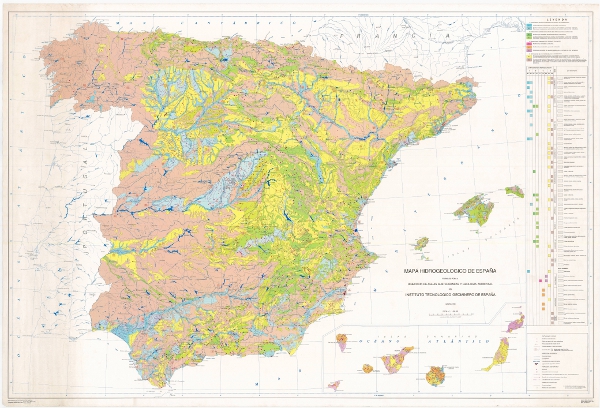
Hydrogeological Map of Spain at a scale of 1:1,000,000, 1991.


The Hydrogeological Map of Spain at a scale of 1:1,000,000 presents the geological units classified according to their hydrogeological character, based on the surface permeability of the outcrops. The hydrogeology is represented by symbolisation of the materials. It is a synthesis of the permeable hydrogeological formations and aquifers at national level, resulting from the systematic studies carried out by the IGME until 1991 on the hydrogeological characteristics of the territory of Spain, determining the location of the aquifers, evaluating their degree of exploitation, hydrodynamic characteristics, resources and reserves, and the quality and contamination of their waters.
The map has been drawn up by the Geological and Mining Institute of Spain in compliance with its specific functions. It covers the national territory of the Iberian Peninsula, the Balearic Islands and the Canary Islands.
The first edition of the Hydrogeological Map of Spain at a scale of 1:1,000,000 corresponds to 1991. A second edition was produced in 1999, incorporating the Hydrogeological Units of Spain into the hydrogeological map.
large_thumbnail
dataset
- ?
Link to the GetCapabilities of the web service hosting the product
- Link to the WMS of the Hydrogeological Map
:
621981
Spanish
Geoscientific information
IGME Thesaurus:
CEOLocation:
GEMET:
GEMET - INSPIRE themes, version 1.0:
 Spatial scope:
Hydrology, Hydrogeology
Hydrology, Hydrogeology.hydrogeological map
Physical and chemical properties.property.property.physical property.permeability
Hydrology, Hydrogeology.aquifer
Physical and chemical properties.property.property.physical property.permeability
General geology.lithology
General geology.geology
COUNTRIES
SPAIN
NATURAL ENVIRONMENT, ANTHROPIC ENVIRONMENT
HYDROSPHERE (freshwater, seawater, waters)
hydrosphere
water (geography)
groundwater
Free:
Hydrogeological formations
Free:
Hydrogeological mapping
Free:
Aquifer formations
Free:
EGDI
-18.25,
27.5,
4.5,
43.75
creation: 1990-01-01, publication: 1991-01-01, revision: 1999-01-01
completed
vector
This map aimed to present in a global and standardised way (UNESCO, IAH), the hydrogeological characteristics of the geological formations and the spatial distribution of the different types of aquifers. It is a synthesis of the hydrogeological knowledge at national level updated up to 1991.
Geological Survey of Spain (IGME-CSIC)
Miguel Mejías Moreno
C/Ríos Rosas, 23,
Madrid,
28003,
España
tel: +34 91 349 57 00
email:
[email protected]
Role: point of contact
Data Quality
The original map is the Hydrogeological Map of Spain at a scale of 1:1,000,000 published in 1991, It is a synthesis of the permeable hydrogeological formations and aquifers at national level, resulting from the systematic studies carried out by the IGME until 1991 on the hydrogeological characteristics of the Spanish territory, determining the location of the aquifers, evaluating their degree of exploitation, hydrodynamic characteristics, resources and reserves, and the quality and contamination of their waters. The map has been prepared by the Geological and Mining Institute of Spain in compliance with its specific functions.
The main sources were:
Geological Map of the Iberian Peninsula, Balearic and Canary Islands at a scale of 1:1,000,000. IGME (1980)
Geological Map of Spain at a scale of 1:200,000. Synthesis of existing cartography. IGME
Groundwater Research Plan, Aquifer Management and Conservation Programme and Urban Water Supply Plan. IGME
Hydrogeological Map of Spain at 1:50.000 and 1:200.000 scale. IGME
National Archive of Water Points. IGME
International Hydrogeological Map of Europe, scale 1:1.500.000. UNESCO-IAH Maps and Memories
Yearbooks of gauging. DGOH, MOPU
Hydrological Plan. MOPU and other Ministries
Several publications on hydrogeology and other specific sources as well as theses and dissertations from different universities.
The digitalisation process of the map and the legend was carried out in 1999 from the printing plates, generating the corresponding coverages in ArcInfo format.
In 1999 the Hydrogeological Map of Spain was republished on paper at a scale of 1:1,000,000, incorporating the Hydrogeological Units of Spain.
Equivalent Scale:
1:
1000000
Constraints
LICENCE OF USE: Conditions of public use and dissemination of information for the re-use of IGME data. https://www.igme.es/condiciones-de-uso/
Metadata about metadata
ESPIGMEHIDRO1M20100217621981
Geological Survey of Spain (IGME-CSIC)
Leticia Vega Martín
C/ Ríos Rosas, 23,
Madrid,
28003,
España
tel: +34 91 349 57 00
email:
[email protected]
Role: point of contact
2025-07-18