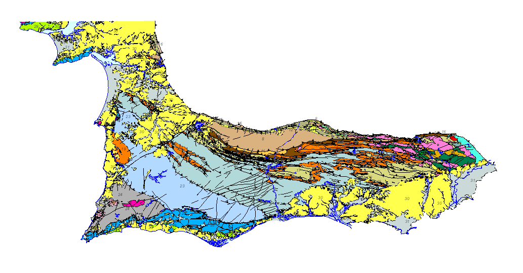
Geological map of the South Portuguese Zone. Scale 1:400.000. 2020 edition.


Geological map of the South Portuguese Zone, at a scale of 1:400,000, in which the geological legend on both sides of the border has been harmonized, with unified criteria between Spain and Portugal. This cartography is a product resulting from the GEO_FPI project: GEO_FPI: cross-border observatory for the geo-economic evaluation of the Iberian Pyrite Belt, financed by the European Regional Development Fund (ERDF) within the program INTERREG V-A Spain– Portugal (POCTEP) 2014-2020. The main beneficiary of the project is the Geological Survey of Spain (IGME-CSIC). Additionally, the General Directorate of Industry, Energy and Mines of the Ministry of Employment, Enterprise and Commerce of the Andalusian Government (JA) and the Portuguese National Laboratory for Energy and Geology (LNEG) and the Municipal Chamber of Aljustrel (CMA) are partners of the project.
large_thumbnail
dataset
WMS visualisation service of the Geological Map of the South Portuguese Area at 1:400.000 scale
- The Web Map Service (WMS) defined by the OGC (Open Geospatial Consortium) makes it possible to view and consult spatially referenced maps. This international standard makes it possible to represent geographic information from different organisations in the form of a digital image.
ArcGIS Server service of the Geological Map of the South Portuguese Area at 1:400.000 scale
- An ArcGIS Server Web service represents a GIS resource, such as a map, locator, or image, that is located in an ArcGIS for Server site and made available to client applications.
Search for the Geological Map of the South-Portuguese Area at scale 1:400.000 in the project Geo_FPI - Cross-border Observatory for the geo-economic valorisation of the Iberian Pyritic Belt.
- IGME page for access to IGME's Geoscientific information
?
:
ESPIGMEGEOFPIGEOLOGICO400
Spanish
Geoscientific information
GEMET - INSPIRE themes, version 1.0:
 Spatial scope:
IGME Thesausus:
Spatial scope:
IGME Thesausus:
Alentejo
Algarve
Andalusia
Cartography
Geology
Chronostratigraphy
Mineralogical deposits
Quarries
Spain
Portugal
Free:
400K
Free:
Industrial rocks and minerals
Free:
Cinturão Pyritic Ibérico.
Free:
Surportuguese zone
Free:
IGME
Free:
LNEG
Free:
EGDI
-9.571999999999999,
36.833,
-5.566,
38.809
creation: 2020-06-01, publication: 2020-06-01
2020-06-01T10:00:00
completed
vector
The main objective of the map is the harmonization of the geological cartography at a 1:400000 scale between Spain and Portugal in the area of the South-Portuguese Zone (ZSP).
Geological Survey of Spain (IGME-CSIC)
Alejandro Díez Montes
,
Salamanca,
37001,
España
tel: +34 923 17 15 01 / 923 26 50 09
email:
[email protected]
Role: author
National Energy and Geology Laboratory, I.P. (LNEG)
João Xavier Matos
,
Aljustrel,
7601-909,
Portugal
tel: +351 210924600/1
email:
[email protected]
Role: author
Data Quality
Geological map of the South Portuguese Zone, at a scale of 1:400,000, in which the geological legend on both sides of the border has been harmonized, with unified criteria between Spain and Portugal. This cartography is a product resulting from the GEO_FPI project: GEO_FPI: cross-border observatory for the geo-economic evaluation of the Iberian Pyrite Belt
Equivalent Scale:
1:
400000
Commission Regulation (EC) No 1205/2008 of 3 December 2008 laying down detailed rules for the implementation of Directive 2007/2/EC of the European Parliament and of the Council as regards metadata
Constraints
LICENCE OF USE: Conditions of public use and dissemination of information for the re-use of IGME data. https://www.igme.es/condiciones-de-uso/
Metadata about metadata
ESPIGMEGEOFPIGEOLOGICO40020201110
Geological Survey of Spain (IGME-CSIC)
Leticia Vega Martín
,
Madrid,
28003,
España
tel: +34 91 349 57 41
email:
[email protected]
Role: point of contact
2026-05-22