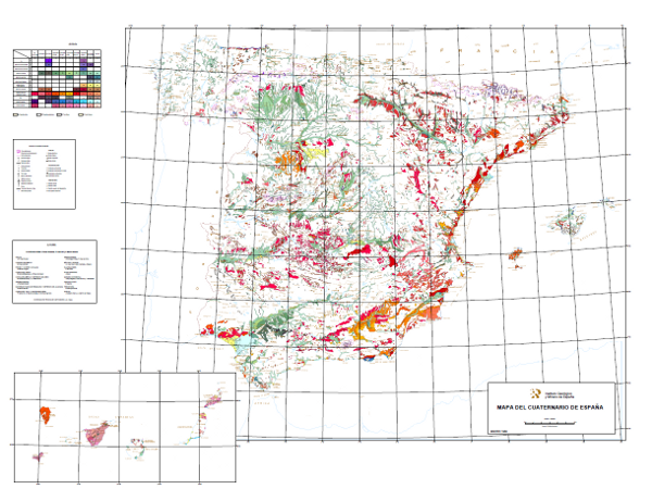
Quaternary map of Spain at a scale of 1:1,000,000


This 1:1,000,000 scale map shows the Plio-Pleistocene to contemporary deposits classified in 10 geochronological intervals and separated according to their genesis. It also includes glacial, volcanic, karstic, aeolian, coastal, edaphic, palaeontological and prehistoric phenomena.
It has been carried out by the Geological Survey of Spain (then called the GeoMining Technological Institute of Spain) with the collaboration of experts mainly from the academic world and public research centres.
It covers the entire national territory, including the archipelagos, with the exception of Melilla.
large_thumbnail
dataset
:
61120
Spanish
Geoscientific information
Society
Society
GEMET - INSPIRE themes, version 1.0:
 IGME Thesaurus:
GEMET:
Spatial scope:
IGME Thesaurus:
GEMET:
Spatial scope:
General geology.geology
Stratigraphy Systematics
Quaternary
Holocene
Pleistocene
Quaternary Geomorphology and Geology.surface formation
Systematics of sedimentary rocks.sediment
Systematics of igneous rocks.volcanic rock
Systematics of sedimentary rocks.clastic sediment.glacial deposition
Sedimentology and sedimentary petrology.fluvial deposition
Marine geology.seabed
Geomorphology and Quaternary Geology.soil
Palaeontology
Stratigraphy.prehistory
NATURAL ENVIRONMENT, ANTHROPIC ENVIRONMENT
LITHOSPHERE (soil, geological processes)
lithosphere
rocks
TERRITORY (landscape, geography)
land
relief form
Free:
Spain
Free:
Fluvial-glacial deposit
Free:
Glacio-lacustrine deposit
Free:
Lake deposit
Free:
Peat bog deposit
Free:
Colluvial deposit
Free:
Aeolian sediment
Free:
Glacis deposit
Free:
Tobas
Free:
EGDI
-18.2,
27.6,
4.31,
43.83
ES
creation: 1988-01-01, publication: 1989-01-01
1988-01-01T10:00:00
completed
vector
The purpose of this map is twofold. On the one hand, to respond to the needs of scientists and planners who require information on aspects of the most recent geology. On the other hand, to reveal and facilitate a national vision of the knowledge of the Quaternary in Spain, a system that is insufficiently known.
Instituto Geológico y Minero de España (IGME-CSIC)
Alejandro Robador Moreno
C/la Calera s/n,
Tres Cantos,
28760,
España
tel: +34 91 349 57 00
email:
[email protected]
Role: point of contact
Data Quality
The map was drawn up from the compilation of cartographic information at scales 1:25,000, 1:50,000 and 1:200,000 produced by the IGME, unpublished cartography, Doctoral Theses, Dissertations and other published works.
Subsequently, the phenomena to be included in the cartography were established and the legend of surface formations was drawn up. Next, the processes of synthesis, reclassification, generalisation and exaggeration were carried out for the final production of the map.
The digitisation process was carried out in 1991 from the printing plates and the definitive normalisation and generation of symbolised files (.lyr) and cartography, in version 8.3 of ArcGis, in 2003.
Equivalent Scale:
1:
1000000
Constraints
LICENCE OF USE: Conditions of public use and dissemination of information for the re-use of IGME data.http://www.igme.es/Ayuda/CondiUso.htm
Metadata about metadata
ESPIGMECUATERNARIO10002010080661120
Instituto Geológico y Minero de España (IGME-CSIC)
Leticia Vega Martín
C/ Ríos Rosas, 23,
Madrid,
28003,
España
tel: +34 91 349 57 00
email:
[email protected]
Role: point of contact
2025-05-09
Coupled Resource
(The rock units of the sheet separated by different types of contacts are represented, together with the tectonic structure, faults and map traces of folds, the orientation and dip of planar and linear elements contained in the rocks, structural and textural singularities of igneous and metamorphic rocks, water points, mineral deposits and indications, presence of fossils and other elements of punctual representation.)
(The rock units of the sheet separated by different types of contacts are represented, together with the tectonic structure, faults and map traces of folds, the orientation and dip of planar and linear elements contained in the rocks, structural and textural singularities of igneous and metamorphic rocks, water points, mineral deposits and indications, presence of fossils and other elements of punctual representation.l)