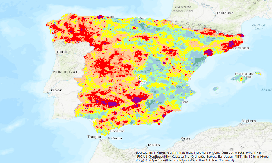
Barium isocontent map (Geochemical Atlas of Spain, 2012)


Iso-content maps of Barium (Ba), one of the chemical elements.obtained in the Geochemical Atlas of Spain Project, distributed in stream sediments (14,864 samples), superficial soils (0-20 cm.) (13,505 samples) and deeper soils (20-40 cm.) (7,682 samples). The results of the chemical analysis are shown in two types: total dissolution of the sample with 4 acids and partial dissolution with aqua regia. With the analytical results of all the sampled points, an isocontent map is made with adjustment to a square grid of 1,000 m by the method of interpolation of the inverse of the squared distance. The final result is a map for each type of sample and type of analysis carried out.
large_thumbnail
dataset
Google Earth service (KML)
- KML is a file format used to display geographic data in an Earth browser such as Google Earth, Google Maps, and Google Maps for mobile. KML uses a tag-based structure with nested elements and attributes and is based on the XML standard.
ArcGIS Server Service for Barium Isovalues (Atlas of Geochemistry, 2012)
- An ArcGIS Server web service represents a GIS resource?such as a map, locator, or image?that is located on an ArcGIS Server site and is made available to client applications.
Information to the Geochemical Atlas of Spain (2012) available on the IGME website
- IGME webpage to access to the Geochemical Atlas of Spain (2012) website
IGME-CSIC
:
ESPIGMEATLASGEOQUIMICABA
Spanish
IGME Thesaurus:
European Geoscience Registry - Projects:
GEMET - INSPIRE themes, version 1.0:
 Spatial Scope:
Geochemistry
Barium
Analysis
Soils
Sediments
Elements
Quality control
Geochemical monitoring
Metallogeny
Atlas
Geochemical map
Sampling
Minerals
Metal
Mineral Resources
Ecosystems
Spain
Free:
Sample
Heatlh
IGCP 259
Free:
Geology
Geochemistry
Mining
-21.223,
27.522,
4.711,
43.829
ES
creation: 2012-01-01, publication: 2012-01-01
2012-01-01T10:00:00
completed
grid
The main objective of this project, co-financed with funds from the European Economic Area (EEA), has been to develop a geochemical knowledge base of the surface materials (stream sediments and soils) of the national territory, both continental and insular, which will allow us to tackle with the necessary information the problems that, for both ecosystems and public health, derive from soil contamination and those related to the geology and mineral resources of Spain.
Iván Martín Méndez
C/Ríos Rosas, 23,
Madrid,
28003,
España
email:
[email protected]
Role: custodian
Margarita Sanabria Pavón
Margarita Sanabria Pavón
C/ Rios Rosas, 23,
Madrid,
28003,
España
email:
[email protected]
Role: processor
?
C/ Rios Rosas, 23,
Madrid,
28003,
España
email:
[email protected]
Role: distributor
Data Quality
Isocontent maps of the chemical elements obtained in the Geochemical Atlas of Spain Project, distributed in stream sediments (14,864 samples), shallow soils (0-20 cm) (13,505 samples) and deeper soils (20-40 cm) (7,682 samples). The results of the chemical analysis are shown in two types: total dissolution of the sample with 4 acids and partial dissolution with aqua regia. With the analytical results of all the sampled points, an isocontent map is made with adjustment to a square grid of 1,000 m by the method of interpolation of the inverse of the squared distance. The final result is a map for each type of sample and type of analysis carried out.
Minimal Distance:
1000 m
Constraints
LICENCE OF USE: Conditions of public use and dissemination of information for the re-use of IGME data. https://www.igme.es/condiciones-de-uso/
Metadata about metadata
ESPIGMEATLASGEOQUIMICABA20210531
Leticia Vega Martín
C/Ríos Rosas, 23,
Madrid,
28003,
España
email:
[email protected]
Role: point of contact
2026-04-13