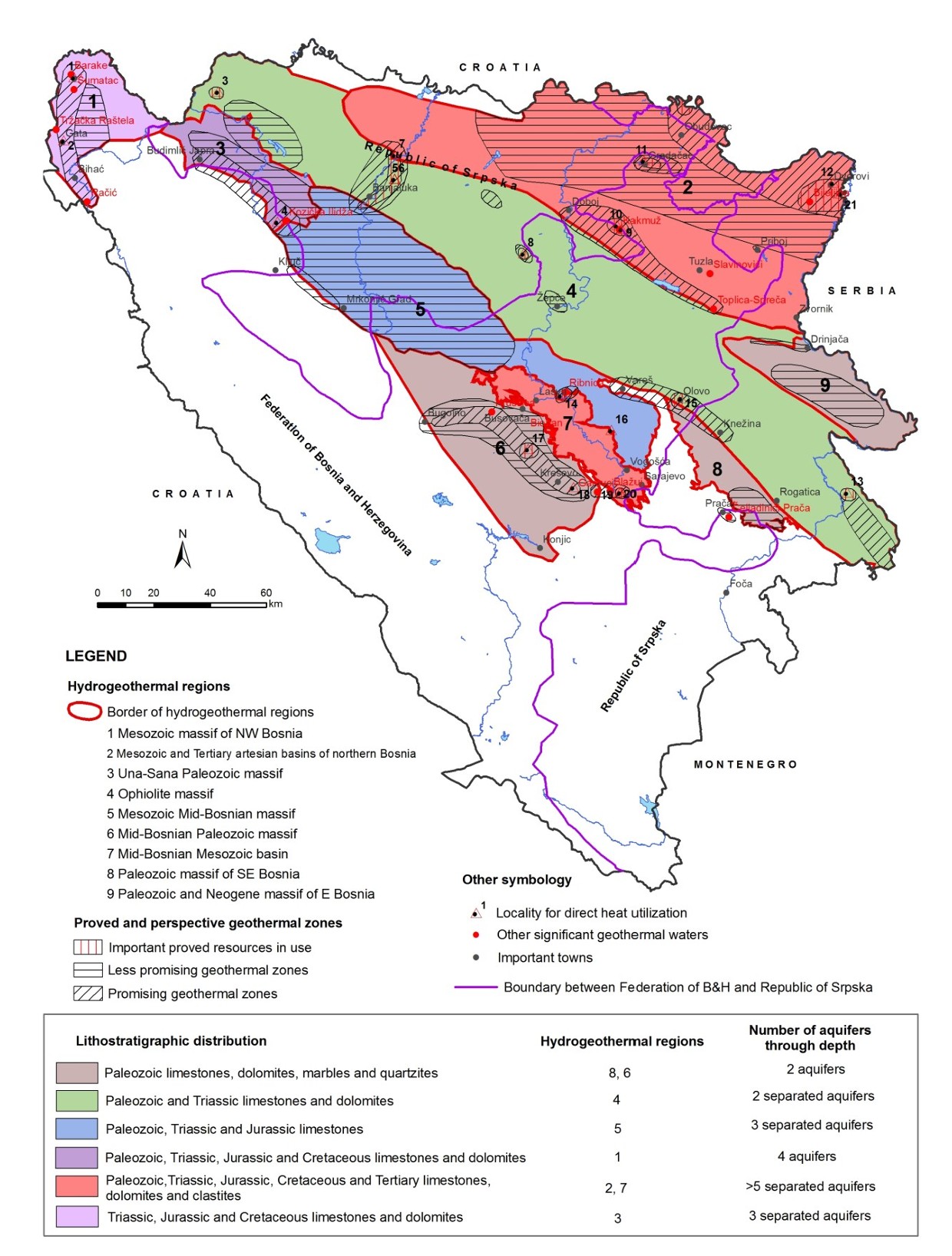
Map of litostratigraphic distribution of aquifers along deepth, hydrogeothermal regions and perspective geothermal zones of Bosnia and Herzegovina


This document provides an overview of geothermal energy research, development, and utilization in Bosnia and Herzegovina during the period 2010–2014. It presents the distribution of hydrogeothermal regions, geothermal reservoirs, principal aquifers, the energy potential of geothermal resources, and their level of utilization. The document also includes information on the direct use of geothermal energy in spas, building heating, and ground-source heat pump systems, as well as an overview of the most significant exploration activities, drilling operations, and the potential for the sustainable development of geothermal energy in Bosnia and Herzegovina.
dataset
Bosnian, English
Environment
Geoscientific information
Inland waters
Geoscientific information
Inland waters
GEMET - INSPIRE themes, version 1.0:


 Spatial scope:
EGDI Keyword Thesaurus:
European Geoscience Registry - Projects:
HVD category:
Spatial scope:
EGDI Keyword Thesaurus:
European Geoscience Registry - Projects:
HVD category:
Free:
geothermal
resources
energy
aquifers
hydrogeothermal
BIH
hydrogeology
EGDI
15.729,
42.555,
19.624,
45.276
creation: 2015
completed
vector, text table, grid
To present the spatial distribution of hydrogeothermal regions, aquifers by depth, and prospective geothermal zones in support of the exploration, planning, and sustainable utilization of geothermal resources in Bosnia and Herzegovina.
Geological Survey of the FBiH
Ferid Skopljak
Ustanička 11,
Ilidža, Sarajevo,
71210,
Bosna i Hercegovina
tel: +38733483367
email:
[email protected]
Role: custodian
Data Quality
The map was produced based on the results of long-term geological, hydrogeological, and geothermal investigations conducted in Bosnia and Herzegovina. The compilation uses data collected from oil and gas exploration, exploratory drilling, geological, geophysical, seismological, and hydrogeological investigations, as well as groundwater and gas analyses carried out from the late 19th century to 2014. The spatial interpretation of hydrogeothermal regions, aquifers, and prospective geothermal zones is based on the synthesis of existing research, published scientific papers, monographs, and the results of long-term regional investigations conducted by the Geological Survey and other relevant institutions.
Equivalent Scale:
1:
300000
Constraints
Use of and access to the data are governed by the applicable regulations and practices of the Geological Survey of the Federation of Bosnia and Herzegovina.
Vector data have restricted use and are provided upon request.
Metadata about metadata
6a69a88c-20ac-49a8-b60a-32f9c0a010e92
Geological Survey of the FBiH
Maida Zejnic
Ustanička 11,
Ilidža, Sarajevo,
71210,
Bosna i Hercegovina
tel: +38733483368
email:
[email protected]
Role: point of contact
2026-08-05