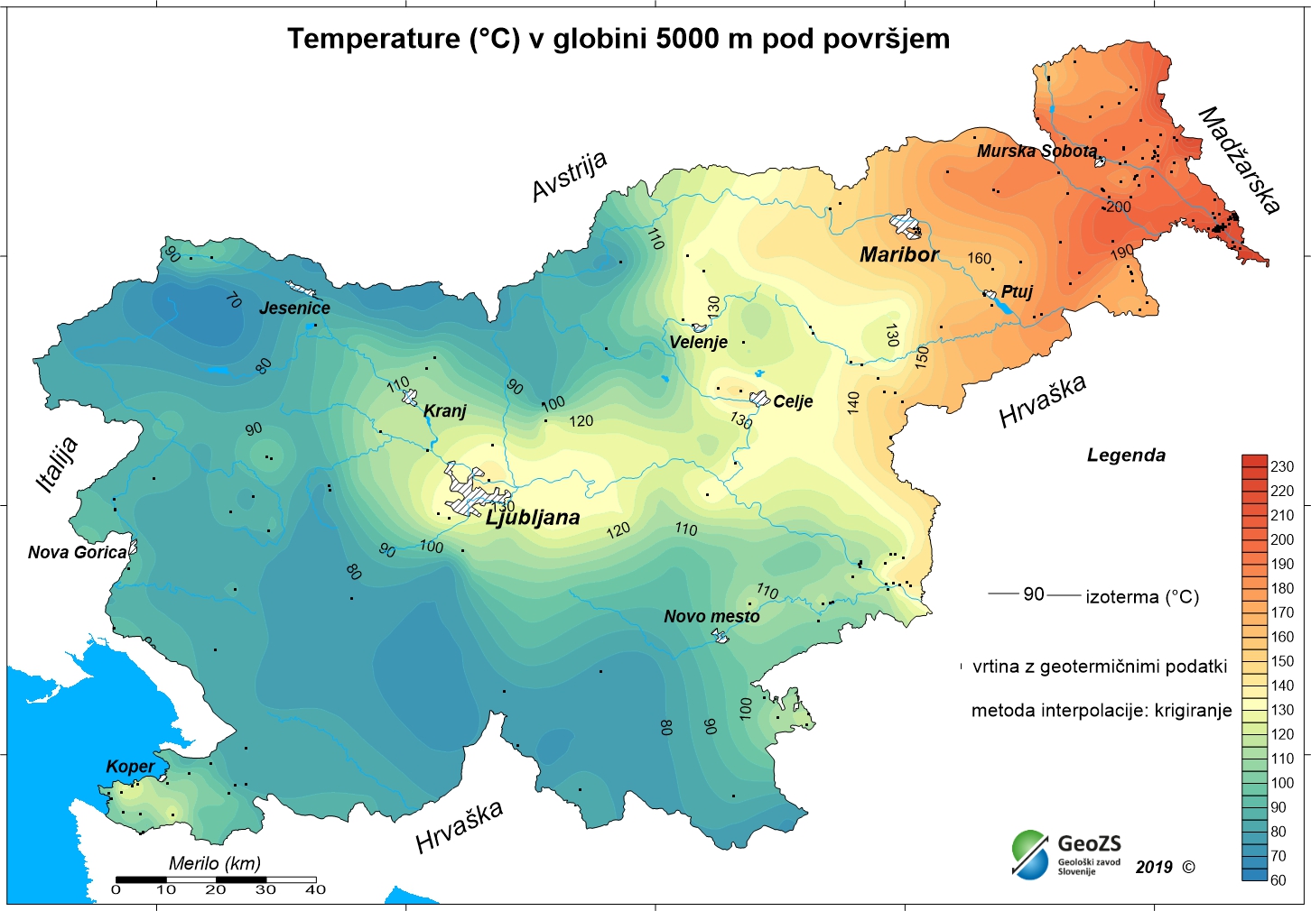
Geothermal map - Expected temperatures at a depth of 5000 m

The underground geothermal conditions can be presented, irrespective of the aquifers' position, with the appropriate geothermal maps. This map represents the expected temperatures at a depth of 5000 m and is made with data from 192 boreholes. It is made on the basis of measured temperatures in accessible boreholes throughout the country. However, since the temperature field depends on the geological structure in the depths and tectonic characteristics, the course of the isotherms is a result of many influences, such as thermal conductivity of rocks, permeability and fracturing of rocks, all of which are reflected in the measured temperatures in boreholes. In this depth also a radiogenic heat production in the rocks has smaller influence, especially in magmatic and metamorphic rocks. The distribution of boreholes, which were useful for the measurement of temperature, is very uneven and different as regard the depths. Following the expected temperatures at a depth of 5000 m a stronger positive anomaly is in the northeastern part of Slovenia, from the line Maribor-Rogatec to the east. In the northeastern part of the country the anomaly is the result of the thinning of the Earth's crust and greater conductive heat flow from the Earth's mantle. Elsewhere temperatures are much lower, especially in the western mountainous parts they are lower than expected mean values for the continents.
large_thumbnail
dataset
ER.t5000_1km
- ?
t_5000_1km.rar
- Geothermal map - Expected temperatures at a depth of 5000 m
SI.GEOZS.GEOTERM.IZO.5000m
:
2a6a90f7-e94e-48ae-8c2b-302e94fddf74
Slovenian
Geoscientific information
GEMET - INSPIRE themes, version 1.0 INSPIRE themes:
Spatial scope:
Energy resources
National
Free:
Slovenia
Free:
geothermal energy
geothermy
temperature map
temperature at 5000 m depth
renewable energy resources
energy balance
hydrogeology
EGDI
Free:
INSPIRE
13.38,
45.42,
16.6,
46.88
creation: 2012-12-31
grid
The purpose of the maps is to improve insight in the geothermal conditions in the depths. With the latest geothermal maps better insight into the geothermal field of Slovenia has been obtained, especially at greater depths. The research results are potentially useful in planning future more detailed studies for the exploitation of geothermal energy. Ultimately, this means determining the micro locations for drilling deep exploration boreholes and exploitation boreholes or wells.
Geological Survey of Slovenia
Dimičeva ulica 14,
Ljubljana,
1000,
Slovenija
tel: +386 1 280 97 00
email:
[email protected]
Role: owner
Geological Survey of Slovenia
mag. Andrej Lapanje
Dimičeva ulica 14,
Ljubljana,
1000,
Slovenija
tel: +386 1 28 09 700
email:
[email protected]
Role: point of contact
Geological Survey of Slovenia
mag. Dušan Rajver
Dimičeva ulica 14,
Ljubljana,
1000,
Slovenija
tel: +386 1 28 09 700
email:
[email protected]
Role: point of contact
Ministry of Infrastructure
Langusova ulica 4,
Ljubljana,
1000,
Slovenija
tel: ?
email:
[email protected]
Role: originator
Geološki zavod Slovenije
?
Dimičeva ulica 14,
Ljubljana,
1000,
Slovenija
tel: +386 1 280 97 00
email:
[email protected]
Role: custodian
Data Quality
Authors:
mag. Dušan Rajver, univ.dipl.ing.geol., dr. Mitja Janža, univ.dipl.ing.geol., mag. Andrej Lapanje, univ.dipl.ing.geol.
mag. Dušan Rajver, univ.dipl.ing.geol., dr. Mitja Janža, univ.dipl.ing.geol., mag. Andrej Lapanje, univ.dipl.ing.geol.
Minimal Distance:
1000 m
Constraints
Metadata about metadata
69c810f9-a2c3-4213-b467-ad719833060e
Geological Survey of Slovenia
Rada Peternel Rikanovič
Dimičeva ulica 14,
Ljubljana,
SI-1000,
Slovenija
tel: +386 1 280 97 00
email:
[email protected]
Role: point of contact
2026-03-02
Coupled Resource
(RAZISKAVE NACIONALNEGA POMENA; Naloga: 3.3 GEOTERMALNI VIRI, december 2012
vir zajema: dokumentacija Geološkega zavoda Slovenije)
vir zajema: dokumentacija Geološkega zavoda Slovenije)