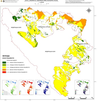
Groundwater Vulnerability Map of the Republic of Srpska 1:300 000


Assessment of the potential threat of groundwater from pollution (i.e. natural vulnerability) is a necessary base for any type of planning and management of groundwater resources. The ultimate goal of the vulnerability map is the subdivision of an area into several units showing the differential degree of vulnerability. Isolated areas or vulnerability classes are presented in different colors or hatches, very easy to understand for the entire professional public, not just geological (which is very important for understanding the results offered by such a map). In combination with risk maps (showing the location and character of pollutants) groundwater vulnerability maps are used as a guide for the location of future developments in an area, in order to minimize the impact that the projected development will have on the surrounding water resources.
dataset
https://data.rzzgi.bh/id/KRPVRS300
English, Serbian
Geoscientific information
GEMET - INSPIRE themes, version 1.0:
 Spatial scope:
EGDI Keyword Thesaurus:
European Geoscience Registry - Projects:
Spatial scope:
EGDI Keyword Thesaurus:
European Geoscience Registry - Projects:
16.194,
42.539,
19.666,
45.293
publication: 2018
2014
-
2018
vector
Long-Term Program for Development of Basic Geological Explorations of the Republic of Srpska
Geological Survey of the Republic of Srpska
Marija Milanović
Вука Караџића 148 Б,
Зворник,
75400,
Bosnia and Herzegovina
tel: +38766425005
email:
[email protected]
Role: custodian
Data Quality
The Groundwater Vulnerability Map of the Republic of Srpska 1:300 000 has been prepared in accordance with the Long-term Program for the Development of Basic Geological Research of the Republic of Srpska. This map is created according to the most contemporary scientific and technical achievements and practices in this field, utilizing modern GIS tools.
Equivalent Scale:
1:
300000
Constraints
Metadata about metadata
66699693-2b90-4d1d-a96e-67290a010855
Geological Survey of the Republic of Srpska
Drazan Tokanović
Вука Караџића 148 Б,
Зворник,
75400,
Bosnia and Herzegovina
tel: +38766425072
email:
[email protected]
Role: point of contact
2026-05-27