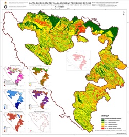
Landslide Susceptibility Map of the Republic of Srpska 1:300 000


Landslide Susceptibility Map of the Republic of Srpska is prepared using the expert AHP methodology and it shows a proposal of the terrain ranking in terms of spatial expectance of landslides in some areas. These maps are very suitable clear maps, comprehensible to experts from different fields, primarily spatial planning, urbanization etc. The preparation of this map, using the modern GIS tools, is a very useful way of prevention and the prerequisite for rational and meaningful struggle against landslides and their negative effects.
dataset
https://data.rzzgi.bh/id/KSTKRS300
English, Serbian
Geoscientific information
GEMET - INSPIRE themes, version 1.0:

 Spatial scope:
EGDI Keyword Thesaurus:
European Geoscience Registry - Projects:
Spatial scope:
EGDI Keyword Thesaurus:
European Geoscience Registry - Projects:
Free:
Landslide susceptibility map
16.194,
42.539,
19.666,
45.293
publication: 2016
2014
-
2016
vector
Long-Term Program for Development of Basic Geological Explorations of the Republic of Srpska
Geological Survey of the Republic of Srpska
Cvjetko Sandić
Вука Караџића 148 Б,
Зворник,
75400,
Bosnia and Herzegovina
tel: +38765349219
email:
[email protected]
Role: custodian
Data Quality
The Landslide susceptibility Map of the Republic of Srpska 1:300 000 has been prepared in accordance with the Long-term Program for the Development of Basic Geological Research of the Republic of Srpska. Establishing a GIS (Geographic Information System) database on landslide for the territory of Republika Srpska, a solid foundation has been created for developing a Landslide susceptibility map of the Republic of Srpska. This map represents a spatial probability map of landslide occurrences in a certain area. It's significant that this map is created according to the most contemporary scientific and technical achievements and practices in this field, utilizing modern GIS tools.
Equivalent Scale:
1:
300000
Constraints
Metadata about metadata
66164724-6bd0-448f-ab1e-23db0a010855
Geological Survey of the Republic of Srpska
Drazan Tokanović
Вука Караџића 148 Б,
Зворник,
75400,
Bosnia and Herzegovina
tel: +38766425072
email:
[email protected]
Role: point of contact
2026-05-27