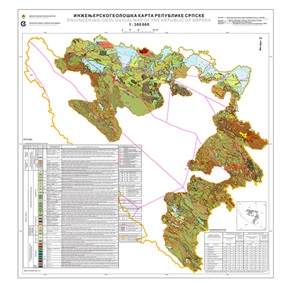
Engineering-Geological Map of the Republic of Srpska
Engineering-geological map of the Republic of Srpska 1:300 000 is the first clear map of Srpska that shows engineering-geological structure of the terrain. Engineering-geological map of the Republic of Srpska 1:300 000 and the Interpreter, contain a general presentation of all elements of the geological environment and provide quick information on all important issues related to engineering geological structure of the terrain, the character of the rocks and soils, condition and properties of rock masses in the function of construction, terrain stability and susceptibility to slope instability, usability of rocks as construction materials and their basic physical and mechanical characteristics as well as basic seismological or seismotectonic characteristics.

dataset
https://data.rzzgi.bh/id/EG300
English, Serbian
Geoscientific information
GEMET - INSPIRE themes, version 1.0:
Spatial scope:
GeoERA Keyword Thesaurus:
Free:
Engineering-geological map
Engineering geology
16.194,
42.539,
19.666,
45.293
publication: 2020
2014
-
2020
vector
Long-Term Program for Development of Basic Geological Explorations of the Republic of Srpska
Geological Survey of the Republic of Srpska (RZZGI)
Dražan Tokanović
Vuka Karadzica 148 B, Zvornik,
75400,
Bosnia and Herzegovina
tel: +387 56 210 413
email:
[email protected]
Role: custodian
Data Quality
The Engineering-geological Map of the Republic of Srpska 1:300 000 has been prepared in accordance with the Long-term Program for the Development of Basic Geological Research of the Republic of Srpska. This map represents the first map showing the engineering geological structure of the territory of the Republic of Srpska. The Geological Map of the Republic of Srpska 1:300 000 and numerous geological and engineering geological documents from the Fund of Expert Documents of the Geological Survey of the Republic of Srpska served as the basis for the production of the Engineering Geological Map of the Republic of Srpska.
Equivalent Scale:
1:
300000
Constraints
Metadata about metadata
66162f28-2458-443d-84db-7f970a010855
Geological Survey of the Republic of Srpska (RZZGI)
Cvjetko Sandić
Vuka Karadžića 148B, Zvornik,
75400,
Bosnia and Herzegovina
tel: +387 56 210 413
email:
[email protected]
Role: point of contact
2025-12-11


