Database of seismogenic zones of the Iberian Peninsula and territories of influence for the calculation of seismic hazard in Spain (ZESIS)


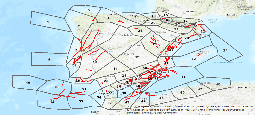
ZESIS is a database of seismogenic zones of the Iberian Peninsula and territories of influence developed for the calculation of the update of the seismic hazard map of Spain (IGN-UPM, 2013). ZESIS is the result of the evolution of three successive models in which numerous researchers from national and international research centres have collaborated, and of the synergy of the FASEGEO (CGL2009-09726), SHARE (FP7-226967), IBERFAULT (CGL2009-07388), OPPEL (IGN-UPM) and SISMOGEN (IGME-CSIC) projects
large_thumbnail
dataset
Download ZESIS: Database of Seismogenic Zones of the Iberian Peninsula and territories of influence.
- Download page from the IGME website
IGME-CSIC
:
ESPIGMEZESIS
Spanish
Geoscientific information
IGME Thesaurus:
GEMET - INSPIRE themes, version 1.0:
 Spatial Scope:
IGME
ZESIS
Seismogenic Zoning of Iberia
Seismogenic Zones
Seismic hazard
QAFI
Quaternary
Fault
Iberia
Earthquake
Paleoseismology
Tectonics
Spain
Portugal
Free:
EGDI
-18.25,
27.5,
4.5,
43.75
creation: 2013-01-01
2013-01-01T10:00:00
onGoing
vector
The main objective of ZESIS is to identify a knowledge infrastructure about the seismogenic zones (artifice of seismic hazard calculation) of the Iberian Peninsula and territories of influence.
Geological Survey of Spain (IGME-CSIC)
Julián García-Mayordomo
Julián García-Mayordomo
,
Tres Cantos,
28760,
España
tel: +34 91 728 7216
email:
[email protected]
Role: custodian
Data Quality
ZESIS is a database of seismogenic zones of the Iberian Peninsula and territories of influence developed for the calculation of the update of the seismic hazard map of Spain (IGN-UPM, 2013). ZESIS is the result of the evolution of three successive models in which numerous researchers from national and international research centres have collaborated, and of the synergy of the FASEGEO (CGL2009-09726), SHARE (FP7-226967), IBERFAULT (CGL2009-07388), OPPEL (IGN-UPM) and SISMOGEN (IGME-CSIC) projects.
COMMISSION REGULATION (EC) No 1205/2008 of 3 December 2008 implementing Directive 2007/2/EC of the European Parliament and of the Council as regards metadata
Constraints
LICENSE OF USE: Conditions of public use and dissemination of information for the reuse of IGME data. https://www.igme.es/condiciones-de-uso/
Metadata about metadata
ESPIGMEZESIS20190703
Geological Survey of Spain (IGME-CSIC)
Leticia Vega Martín
C/Ríos Rosas, 23,
Madrid,
28003,
España
email:
[email protected]
Role: point of contact
2026-05-22
Coupled Resource
(ZESIS, the database of seismogenic zones of the Iberian Peninsula and territories of influence, was the result of the evolution of three successive models in which numerous researchers from both national and international research centres have collaborated, and of the synergy of the FASEGEO (CGL2009-09726), SHARE (FP7-226967), IBERFAULT (CGL2009-07388), OPPEL (IGN-UPM) and SISMOGEN (IGME-CSIC) projects.)