WMS of the Lithostratigraphic Map of Spain at scale 1:200,000 of the Geological Survey of Spain


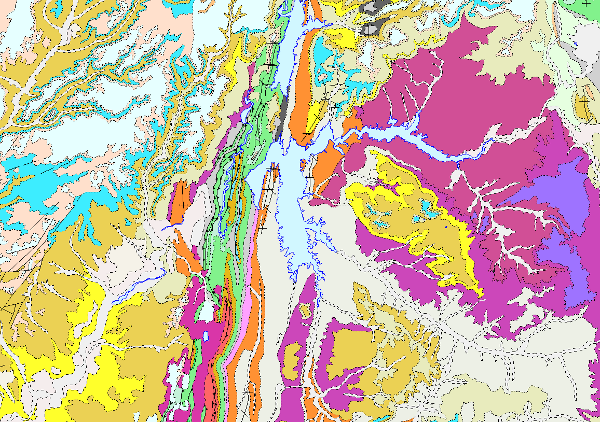
The continuous lithostratigraphic map of Spain in digital format at a scale of 1:200,000 represents the cartographic units characterised mainly according to lithostratigraphic and hydrogeological criteria. The criteria maintained to consider their cartographic representation are to maintain those units that present an important lithostratigraphic development, both for their representation and their singularity, also incorporating those that show a high hydrogeological interest, either because of their own lithological nature (high permeability) or because they are considered to form an essential part of the definition of the aquifer. The contacts between the cartographic units represented were normal, unconformable and intrusive contacts. Faults, thrusts and folding structures are represented. Thus, a continuous map has been obtained in digital format, in which there are still areas with a higher density of cartographic information than others, either because they come from synthesis maps made with less general criteria than these, or because for their preparation, smaller scale cartographies (e.g. 1:50,000) have been used, thus obtaining a much richer and more detailed cartography. This map is the basis for the permeability and hydrogeological maps of Spain at a scale of 1:200,000 continuous and in digital format. This cartography is adapted to the hydrographic network and the shadow model made by CEDEX, at a scale of 1:200,000, from the topographic base, at a scale of 1:50,000, of the Army Cartographic Service. Given the scale of detail of this cartography, the availability of the entire national territory, and the impossibility of appreciating the detail it possesses at small scales, the information is only visualised from the visualisation scale indicated in the Capabilities file.
large_thumbnail
service
- Servicio
IGME-CSIC
:
WMS_LITOESTRATIGRAFICO200CD
view
GEMET - INSPIRE themes, version 1.0:
 CEOLocation:
IGME Thesaurus:
Spatial scope:
ISO 19119:
INSPIRE_SpatialDataServicesClassification:
Web Services Specifications:
CEOLocation:
IGME Thesaurus:
Spatial scope:
ISO 19119:
INSPIRE_SpatialDataServicesClassification:
Web Services Specifications:
SPAIN
COUNTRIES
Hydrology, Hydrogeology
hydrogeology
Map access service
infoMapAccessService
Geographic modelling/information management service
infoManagementService
OGC (Open Geospatial Consortium)
WMS (Web Map Service)
WMS 1.3.0
OGC
WMS
Free:
IGME
IDEE
Lithostratigraphic
ewater
Spain
Free:
EGDI
-21.259,
27.475,
4.77,
43.888
creation: 2009-03-01, publication: 2009-03-01
completed
Geological Survey of Spain (IGME-CSIC)
?
email:
[email protected]
Role: point of contact
Data Quality
Reglamento (UE) n o 1089/2010 de la Comisión de 23 de noviembre de 2010 por el que se aplica la Directiva 2007/2/CE del Parlamento Europeo y del Consejo en lo que se refiere a la interoperabilidad de los conjuntos y los servicios de datos espaciales
REGLAMENTO (CE) No 1205/2008 DE LA COMISIÓN de 3 de diciembre de 2008 por el que se ejecuta la Directiva 2007/2/CE del Parlamento Europeo y del Consejo en lo que se refiere a los metadatos
Constraints
LICENCE OF USE: Conditions of public use and dissemination of information for the re-use of IGME data. https://www.igme.es/condiciones-de-uso/
Metadata about metadata
ESPIGMESERVICIOLITOESTRATIGRAFICO200CONTINUODIGITAL20110221637841
Geological Survey of Spain (IGME-CSIC)
Leticia Vega Martín
C/ Ríos Rosas, 23,
Madrid,
28003,
España
tel: +34 91 349 57 00
email:
[email protected]
Role: point of contact
2025-07-18