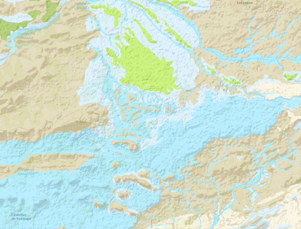
WMS of the Hydrogeological Map of Spain at scale 1:200.000 of the Geological Survey of Spain
The continuous Hydrogeological Map of Spain in digital format at a scale of 1:200,000 is based on the Lithostratigraphic and Permeability Map of Spain, continuous at a scale of 1:200,000 and represents the mapped lithostratigraphic levels, grouped by range of permeability and the associated lithologies, and represented with a certain colour and tone, so that it is possible to visualise the areas associated with the different aquifers on the map. Blue colours represent porous aquifers, green colours represent fissured or karstic aquifers and brown colours represent impermeable or low permeability formations. Productivity is represented by tone, in the case of permeable formations, darker tones indicate higher productivity and in the case of impermeable formations indicate higher impermeability. Given the scale of detail of this cartography, the availability of the entire national territory, and the impossibility of appreciating the detail it possesses at small scales, the information is only visualised from the visualisation scale indicated in the Capabilities file.

large_thumbnail
service
- Servicio
IGME-CSIC
:
WMS_HIDROGEOLOGICO200CD
view
ISO 19119:
ISO - 19119 geographic services taxonomy.:
GEMET - INSPIRE themes, version 1.0:
Tesauro IGME:
infoMapAccessService
Map access service
Physical and chemical properties
property
physical propertyI
permeability
Hydrology, Hydrogeology
hydrogeology
Hydrology, Hydrogeology
hydrogeology
Free:
IGME
IDEE
ewater
Spain
Free:
EGDI
-21.26,
27.47,
4.77,
43.89
creation: 2009-03-01
Geological Survey of Spain (IGME-CSIC)
?
email:
[email protected]
Role: point of contact
Data Quality
Constraints
Metadata about metadata
ESPIGMESERVICIOHIDROGEOLOGICO200CONTINUODIGITAL20110221637843
Geological Survey of Spain (IGME-CSIC)
Leticia Vega Martín
C/ Ríos Rosas, 23,
Madrid,
28003,
España
tel: +34 91 349 57 00
email:
[email protected]
Role: point of contact
2025-07-18


