View Service (WMS) of Geological Map of Spain at scale 1:200.000


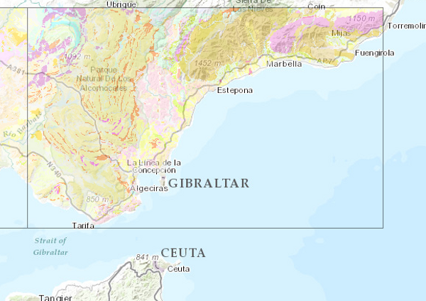
Map showing the chronolithostratigraphic units of the area covered by the sheet separated by different types of contacts: normal or concordant, discordant, intrusive and other. The tectonic structure is represented by the cartographic traces of folds, the orientation and dip of planar and linear elements contained in the rocks, as well as by the structural relationship - through faults and thrusts - between the cartographically differentiated rock assemblages. Unique features of the igneous rocks as well as the degree of migmatisation of the metamorphic rocks are also depicted. The map is accompanied by the lithostratigraphic legend and conventional signs.
large_thumbnail
service
- Servicio
IGME-CSIC
:
WMS_GEOLOGICO200
view
GEMET - INSPIRE themes, version 1.0:
 CEOLocation:
Spatial scope:
ISO 19119:
INSPIRE_SpatialDataServicesClassification:
Web Services Specifications:
CEOLocation:
Spatial scope:
ISO 19119:
INSPIRE_SpatialDataServicesClassification:
Web Services Specifications:
COUNTRIES
SPAIN
Map access service
infoMapAccessService
Geographic modelling/information management service
infoManagementService
OGC (Open Geospatial Consortium)
WMS (Web Map Service)
WMS 1.3.0
OGC
WMS
Free:
IGME
IDEE
Spain
Geologico200
Free:
EGDI
-18.167,
27.642,
4.337,
43.793
publication: 2010-01-01
Geological Survey of Spain (IGME-CSIC)
?
email:
[email protected]
Role: point of contact
Data Quality
Commission Regulation (EU) No 1089/2010 of 23 November 2010 implementing Directive 2007/2/EC of the European Parliament and of the Council as regards the interoperability of spatial data sets and services
COMMISSION REGULATION (EC) No 1205/2008 of 3 December 2008 implementing Directive 2007/2/EC of the European Parliament and of the Council as regards metadata
Constraints
LICENSE OF USE: Conditions of public use and dissemination of information for the reuse of data. https://www.igme.es/condiciones-de-uso/
Metadata about metadata
ESPIGMESERVICIOGEOLOGICO2002011021522100
Geological Survey of Spain (IGME-CSIC)
Leticia Vega Martín
C/ Ríos Rosas, 23,
Madrid,
28003,
España
tel: +34 91 349 57 00
email:
[email protected]
Role: point of contact
2026-06-04