Service of visualization (WMS) of Geological age map of the Iberian Peninsula, Balearic and the Canary islands at a scale of 1:1,000,000


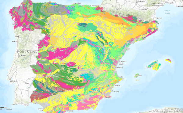
The geological age map of the units at a scale of 1:1,000,000 has been generated from the information in the chronolithostratigraphic column of the map. In all units the System has been specified, the Series has only been covered in about half of the units and the Floor is occasional. In cases where it has not been possible to establish a chronostratigraphic section, the value "undetermined" has been assigned.
large_thumbnail
service
- Servicio
IGME-CSIC
:
WMS_EDADES1000
view
GEMET - INSPIRE themes, version 1.0:
 CEOLocation:
EuropeanTerritorialUnits:
Spatial scope:
ISO 19119:
INSPIRE_SpatialDataServicesClassification:
Web Services Specifications:
CEOLocation:
EuropeanTerritorialUnits:
Spatial scope:
ISO 19119:
INSPIRE_SpatialDataServicesClassification:
Web Services Specifications:
COUNTRIES.
SPAIN
Spain
Map access service
infoMapAccessService
Geographic modelling/information management service
infoManagementService
OGC (Open Geospatial Consortium)
WMS (Web Map Service)
WMS 1.3.0
OGC
WMS
Free:
IGME
IDEE
Ages.
Free:
EGDI.
-22.719,
26.602,
6.257,
44.66
creation: 2009-03-01, publication: 2009-03-01
Geological Survey of Spain (IGME-CSIC)
?
email:
[email protected]
Role: point of contact
Data Quality
Commission Regulation (EU) No 1089/2010 of 23 November 2010 implementing Directive 2007/2/EC of the European Parliament and of the Council as regards the interoperability of spatial data sets and services
COMMISSION REGULATION (EC) No 1205/2008 of 3 December 2008 implementing Directive 2007/2/EC of the European Parliament and of the Council as regards metadata
Constraints
LICENCE OF USE: Conditions of public use and dissemination of information for the re-use of IGME data. https://www.igme.es/condiciones-de-uso/
Metadata about metadata
ESPIGMESERVICIOEDADESGEOLOGICAS100020110216260472
Geological Survey of Spain (IGME-CSIC)
Leticia Vega Martín
C/ Ríos Rosas, 23,
Madrid,
28003,
España
tel: +34 91 349 57 00
email:
[email protected]
Role: point of contact
2026-05-22