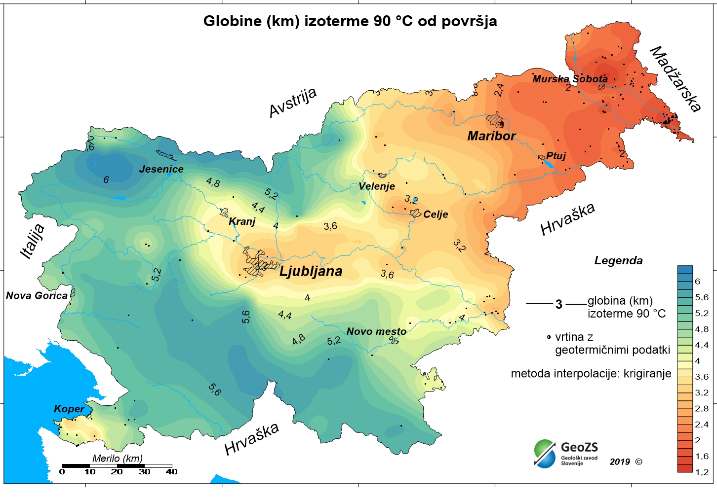
Geothermal map - Depths of the 90°C isotherm

The underground geothermal conditions can be presented, irrespective of the aquifers' position, with the appropriate geothermal maps. This map shows the expected depths of the isotherm of 90 °C and is made with data from 191 boreholes. In a way, it is the inverse of those ordinary temperature maps showing the temperature at certain depths. It is made on the basis of measured temperatures in accessible boreholes throughout the country. However, since the temperature field depends on the geological structure in the depths and tectonic characteristics, the course contours result of many influences, such as thermal conductivity of rocks, permeability and fracturing of rocks, all of which are reflected in the measured temperatures in boreholes. The distribution of boreholes, which were useful for the measurement of temperature, is very uneven, and different as regard the depths. The map of depths to 90 °C isotherm shows a positive anomaly in the northeastern part of Slovenia. As a result of thin Earth's crust in the area and the higher conductive heat flow from the Earth's mantle, there are higher temperatures and thus are inversely smaller depths to isotherm of 90 °C.
dataset
ER.gl_iso90c_slo
- ?
gl_iso90_slo.rar
- Geothermal map - Depths of the 90°C isotherm
SI.GEOZS.GEOTERM.IZO.90C
:
cd048766-d5fa-4788-b5f9-ff2862da1b7a
Slovenian
Geoscientific information
GEMET - INSPIRE themes, version 1.0:
Spatial scope:
Energy resources
National
Free:
Slovenia
geothermal energy
geothermy
temperature map
depth of the isotherm 90°C
renewable energy resources
energy balance
hydrogeology
EGDI
INSPIRE
Free:
13.38,
45.42,
16.6,
46.88
creation: 2012-12-31
grid
The aim is to improve access to the geothermal conditions in the depths. This map shows the expected depths of the isotherm of 90 ° C.
Geological Survey of Slovenia
Dimičeva ulica 14,
Ljubljana,
1000,
Slovenija
tel: +386 1 280 97 00
email:
[email protected]
Role: owner
Geological Survey of Slovenia
mag. Andrej Lapanje
Dimičeva ulica 14,
Ljubljana,
1000,
Slovenija
tel: +386 1 28 09 700
email:
[email protected]
Role: point of contact
Geological Survey of Slovenia
mag. Dušan Rajver
Dimičeva ulica 14,
Ljubljana,
1000,
Slovenija
tel: +386 1 28 09 700
email:
[email protected]
Role: point of contact
Ministry of Infrastructure
Langusova ulica 4,
Ljubljana,
1000,
Slovenija
tel: ?
email:
[email protected]
Role: originator
Geološki zavod Slovenije
?
Dimičeva ulica 14,
Ljubljana,
1000,
Slovenija
tel: +386 1 280 97 00
email:
[email protected]
Role: custodian
Data Quality
Authors: mag. Dušan Rajver, univ. dipl. inž. geol., mag. Joerg Prestor, univ. dipl. inž. geol., Simona Pestotnik, univ.dipl. inž. vod. in kom.inž., mag. Andrej Lapanje, univ. dipl. inž. geol., dr. Mitja Janža, univ. dipl. inž. geol., Simon Mozetič, tehn. sod., dr. Nina Rman, univ. dipl. inž. geol.
Minimal Distance:
1000 m
Constraints
Metadata about metadata
C211EED2-54CA-4F43-8E85-EF59696A73CC
Geological Survey of Slovenia
Rada Peternel Rikanovič
Dimičeva ulica 14,
Ljubljana,
SI-1000,
Slovenija
tel: +386 1 280 97 00
email:
[email protected]
Role: point of contact
2026-05-26
Coupled Resource
(RAZISKAVE NACIONALNEGA POMENA; Naloga: 3.3 GEOTERMALNI VIRI, december 2012
vir zajema: dokumentacija Geološkega zavoda Slovenije)
vir zajema: dokumentacija Geološkega zavoda Slovenije)