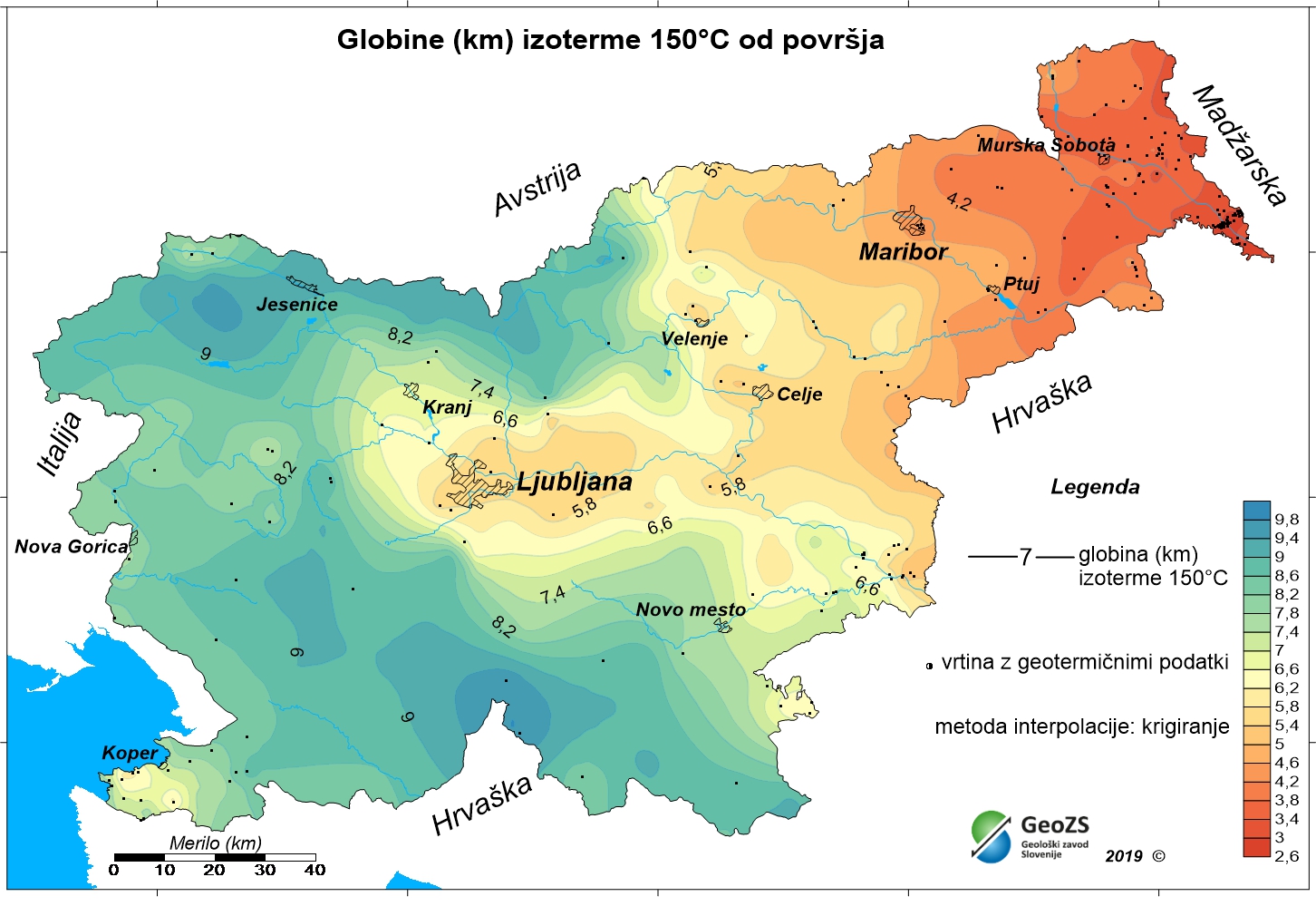
Geotermična karta - Karta pričakovane globine do izoterme 150 °C

Podzemni geotermični pogoji se ne glede na lego vodonosnikov prikazujejo s primernimi geotermičnimi kartami. Ta karta predstavlja pričakovane globine do izoterme 150 °C in je izdelana s podatki iz 191 vrtin. Na nek način je inverzna tistim navadnim temperaturnim kartam, ki kažejo temperature v določenih globinah. Izdelana je na podlagi izmerjenih temperatur v dostopnih vrtinah po celi državi. Ker pa je temperaturno polje odvisno od geološke sestave v globinah in tektonskih značilnosti, je potek izolinij rezultat številnih vplivov, kot so toplotne prevodnosti kamnin, prepustnost in razpokanost kamnin, ki se vsi odražajo v izmerjenih temperaturah v vrtinah. Seveda pa je prepustnost in razpokanost kamnin vse manjša v večjih globinah, ki so za to karto v zahodni in južni ter delu severne Slovenije že kar velike do te izoterme. Porazdelitev vrtin, ki so bile uporabne za meritve temperature, pa je zelo neenakomerna in po globinah različna. Karta globin do izoterme 150 °C prikazuje pozitivno anomalijo v severovzhodnem delu Slovenije. Kot posledica tanjše Zemljine skorje na tem območju in višjega konduktivnega toplotnega toka iz plašča Zemlje, so tam najvišje temperature, s tem pa so obratno najmanjše globine do izoterme 150 °C.
dataset
ER.gl_iso150_slo
- ?
gl_iso_150_slo.rar
- Geotermična karta - Karta pričakovane globine do izoterme 150 °C
SI.GEOZS.GEOTERM.IZO.150C
:
280ab92c-734d-4eac-bf21-f44a79af2526
Slovenian
Geoscientific information
GEMET - INSPIRE themes, version 1.0:
Spatial scope:
Energetski viri Energy resources
Nacionalno
Free:
Slovenija
geotermalna energija
geotermija
temperaturne karte
globina izoterme 150 °C
obnovljivi viri energije
energetska bilanca
hidrogeologija
EGDI
INSPIRE
Free:
13.38,
45.42,
16.6,
46.88
creation: 2012-12-31, publication: 2012-12-31
grid
Namen je izboljšati vpogled v geotermične razmere v globinah. Karta prikazuje pričakovane globine do izoterme 150 °C.
Geološki zavod Slovenije
Ljubljana,
1000,
Slovenija
tel: +386 1 280 97 00
email:
[email protected]
Role: owner
Geološki zavod Slovenije
Ljubljana,
1000,
Slovenija
tel: +386 1 28 09 700
email:
[email protected]
Role: point of contact
Geološki zavod Slovenije
Ljubljana,
1000,
Slovenija
tel: +386 1 28 09 700
email:
[email protected]
Role: point of contact
Ministrstvo za infrastrukturo
Ljubljana,
1000,
Slovenija
tel: ?
email:
[email protected]
Role: originator
Geološki zavod Slovenije
?
Dimičeva ulica 14,
Ljubljana,
1000,
Slovenija
tel: +386 1 280 97 00
email:
[email protected]
Role: custodian
Data Quality
Avtorji: mag. Dušan Rajver, univ. dipl. inž. geol., mag. Joerg Prestor, univ. dipl. inž. geol., Simona Pestotnik, univ.dipl. inž. vod. in kom.inž., mag. Andrej Lapanje, univ. dipl. inž. geol., dr. Mitja Janža, univ. dipl. inž. geol., Simon Mozetič, tehn. sod., dr. Nina Rman, univ. dipl. inž. geol.
Minimal Distance:
1000 m
Constraints
Metadata about metadata
315486f6-3aec-4ac0-a222-0233a78c13a9
Geološki zavod Slovenije
Ljubljana,
SI-1000,
Slovenija
tel: +38612809700
email:
[email protected]
Role: point of contact
2026-05-26
Coupled Resource
(RAZISKAVE NACIONALNEGA POMENA; Naloga: 3.3 GEOTERMALNI VIRI, december 2012
vir zajema: dokumentacija Geološkega zavoda Slovenije)
vir zajema: dokumentacija Geološkega zavoda Slovenije)