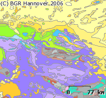
The 1:5 Million International Geological Map of Europe and Adjacent Areas (IGME5000) (WMS)
The 1:5 Million International Geological Map of Europe and Adjacent Areas shows the pre-Quaternary geology of Europe onshore and offshore. In addition to the geology attributed by age, petrography and genesis, also magnetic anomalies, tectonic structures, metamorphism and – in the offshore areas – information about the continental/oceanic crust and the continental margin, are shown. The map was developed by BGR under the umbrella of the Commission of the Geological Map of the World (CGMW) and in cooperation with geological surveys organisations of 48 countries and more than 20 research institutes. For detailed information about the 'IGME 5000: More than just a map – A multinational GIS Project' please visit the IGME website.

service
- Geologie
:
7A4A2412-0B32-4FF1-86B0-A565EDDD5EF2
view
OGC:WMS 1.3.0
GEMET - INSPIRE themes, version 1.0:
ISO 19119:
Geologie
geology
infoMapAccessService
Free:
WMS
EGDI
igme5000
GeolDG
Free:
Europa
-11.00,
34.00,
63.00,
80.00
publication: 2005-11-21
completed
Bundesanstalt für Geowissenschaften und Rohstoffe
Asch, Kristine, Dr.
Stilleweg 2,
Hannover,
30655,
DE
email:
[email protected]
Role: point of contact
Bundesanstalt für Geowissenschaften und Rohstoffe (BGR)
email:
[email protected]
Role: custodian
Data Quality
VERORDNUNG (EG) Nr. 976/2009 DER KOMMISSION vom 19. Oktober 2009 zur Durchführung der Richtlinie 2007/2/EG des Europäischen Parlaments und des Rates hinsichtlich der Netzdienste
Constraints
Allgemeine Geschäftsbedingungen, s.: https://www.bgr.bund.de/AGB - General terms and conditions, s. https://www.bgr.bund.de/AGB_en; Die bereitgestellten Informationen sind bei Weiterverwendung wie folgt zu zitieren: Datenquelle: IGME5000, (c) BGR Hannover, 2007
Metadata about metadata
2C7FF681-216B-4794-A8DC-F79B046F86F9
Bundesanstalt für Geowissenschaften und Rohstoffe (BGR)
,
DEU
email:
[email protected]
Role: point of contact
2024-03-04

